Barometric Altimeter Short-Term
Accuracy Analysis
Wang Tang
Ching Yun University
Gene Howell
ARINC
&
Yi·Hsueh Tsai
National Taiwan
University
·· '
ABSTRACT
r
·
Although it is mandatory to have at least one barometric
altimeter installed in each and every aircraft flying within
ally air trafflc controUed
regions
to assure vertical
separation, the absolute accuracy of such an instrument is
rather poor and limited. Basically; a barometric altimeter
is a pressure sensor. It measures the atmospheric static
pressure and translates it to the vertical height using a
predetermined formula. However, as long as all aircraft
are equipped with the same kinds of instruments, the
52."
vertical separation in any controlled air space is assured.
Until recent years, all flight levels
(FL)
above 290 must be
separated by 2000 feet. It was accomplished this way
primarily because of the unknown performance of
..,."
-5
LDI'IQII\AM (degrM)
51.2
barometric altimeters. By reason of increasing congestion
in the air traffic routes near the North Atlantic, the Federal
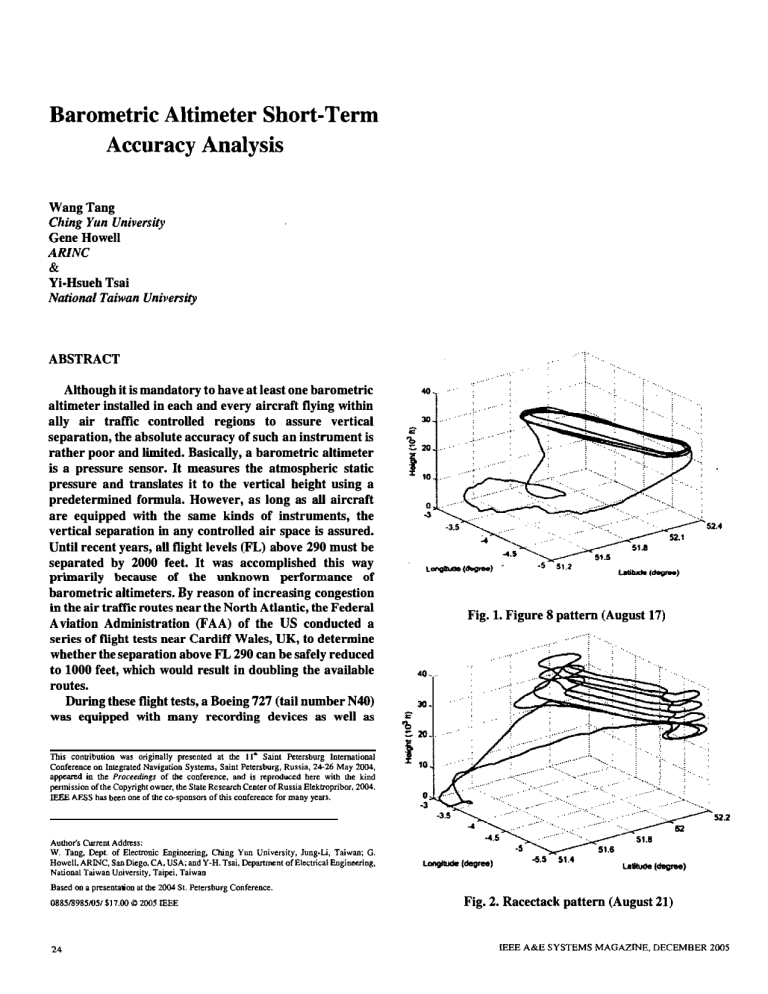
Fig. 1. Figure 8 pattern (August 17)
A viation Administration (FAA) of the US conducted a
series of flight tests near Cardiff
Wales, UK, to determine
whether the separation above FL 290 can be safely reduced
to 1000 feet, which would result in doubling the available
routes.
. . ..
During these flight tests, a Boeing 727 (tail number N40)
was equipped with many recording devices as well as
This
30
..... '
conlribution was originally presented at the II· Saint Petersburg International
. !� ....
Conference on Integrated Navigation Systems, Saint Petersburg, Russia, 24-26 May 2004,
appeared in the Proceedinl!s of the conference, and is reproduced here with the kind
pennission of the Copyright owner, the State Research Ceoter of Russia Elektropribor,
IEEE AESS
has been one of the co· sponsors of this conference for many years.
Authors Current Address:
W. Tang, Dept. of Electronic
2004.
Engineering, Ching Yun University, Jung-U, Taiwan; G.
Howell, ARINC, San Diego, CA, USA; and Y·H. Tsai, Department of Electrical Engineering,
. ,.'
o
-3
. ...
'.
...
..... . .....
. ..
. ...
'r
-6.5
. ....
..•
...
: . : ...
'
.
' :
:J" ..
.
,
. . .... .
.. .:.
.� .
..
•.
.,
, .:"": '"
.
. ....
522
51.4
National Taiwan University, Taipei, Taiwan
Based 00 a presentation at the 2004 St. Petersburg Conference.
0885/8985/051 $17.00 � 2005 IEEE
24
Fig. 2. Racectack pattern (August 21)
IEEE A&E SYSTEMS MAGAZINE, DECEMBER 2005
6
4
2
� 0
'<It
�\\\I\VV
I
.c
�
I
1\
'
�. ,\
,1
4
3
2
V r��\{ ��lri vv�t
11
f
50
0
i
·1
f
�
o
·2
100
150
300
250
200
time (5)
450
400
350
� I�
�
��!
g1
·3
0
50
100
150
Fig. 3. August 17
200
250
300
lime (&)
350
400
450
500
Fig. 4. August 21
Table 1. Summ ary of Results
Summary of results
August 17
Time
Index
Variance
August 18
TIme
Index
(I)
Variance
August 21
August 18 (2)
TIme
Index
Variance
TIme
Index
Variance
630-1150
2.8467
906-1330
1.1999
601-1065
2.9575
961-1416
1.4533
1441-1871
2.1936
1492-1749
1.5711
1354-1806
2.8273
1574-2086
1 8494
2180-2602
2.1497
2863-3040
2.1415
2143-2238
1.6479
2216-2657
4.671 0
.
2969-3414
1.9583
3350-3731
2.9814
2291-2745
3.1000
2820-3307
3.4176
3695-4115
2.3938
4515-4730
2.4687
3024-3476
3 .3 463
4515-4970
2.6964
4873-5135
5.0704
3815-4310
3.1504
3432-3889
4138-4575
2.01 76
1 5432
5199-5269
1.3684
5617-5836
1.5607
4650-5276
3.9594
4703-5164
2.5500
.
5298-5745
2.9962
6326-6836
2.6478
5381-5464
1.2656
5323-5818
1.9479
6177-6560
1.9644
6982-7390
1.5385
5512-5972
3.7516
5957-6401
3.4569
6817-7273
3.0070
7584-7932
1.5025
6286-6721
2.5150
6558 7078
1.6533
Average
2.3575
Average
2.3105
Average
2.8521
Average
2.3236
Global Positioning System (GPS). The GPS receiver had
capabilities of measuring carrier phase of the received
signals so that 3-D positions with respect to WGS-84 during
the entire ffights can be determined down to centimeter
accuracy. Among the four (4) takeoff-landing testsJ the
aircraft conducted these tests using two flying patterns
alternatively: Figure-8 with flight level gradually increased
from FL 290 to 410 and Racetrack with constant flight
level.
We observed that the
barometric altimeter
measurements resemble the kinematic GPS altitude closely
except an apparent low frequency difference. In other
wordsJ the barometric altimeter had short-term accuracYJ
which would be as good as the kinematiC GPS. The
objective of this paper is to document these fmdings. Based
on the actual dataJ we conclude that barometric altimeters
are extremely accurate sensors for altitude in the sense of
short-term accuracy.
IEEE A&E SYSTEMS MAGAZINE, DECEMBER 2005
-
INTRODUCTION
The Federal Aviation Administration (FAA) of the United
States (US) conducted a series of flight tests near the southwest
comer of the United Kingdom (UK) in 1995. The primary
objective of these tests was to evaluate the performance of two
monitoring systems; namely: the GPS-based Monitoring Unit
(GMU) and the Height Monitoring Unit (HMU). The GMU is a
portable system that can be carried onto an aircraft by a tester
to record GPS measurements to be processed further on the
ground with differential corrections [1]. The HMU is a
land-based system to
determine
aircraft height by the
triangulation technique from Mode·C signals. Both were
designed to monitor whether an aircraft can meet Reduced
Vertical Separation Minimum (RVSM) requirements. RVSM
regions are defined so that vertical separation of aircraft can be
reduced from 2000 feet to 1000 feet for FL290 to FL41 O.
In order to evaluate these highly accurate GMU and HMU
systems, an even more accurate reference system, preferably
25
an order of magnitude better, is needed. Naturally, kinematic
declared adequate to monitor aircraft accuracy of
GPS (KGPS) could achieve such a goal. Unlike differential
barometric
GPS (DGPS) using differentially derived corrections to
objectives were all met, the first-named author
compensate pseudo-range measurements, KGPS only uses the
noticed that the recorded barometric altimeter
double
recordings had many similarities with KGPS
difference
method
to
process
carrier
phase
measurements. Because the wavelength of the GPS Ll signal is
few degrees, KGPS
Although
main
FAA
results. They synchronized to each other very
19 centimeters and carrier phase measurement accuracy is
about a
altimeters.
well in the short-term sense. Unfortunately, this
could potentially provide
kind of comparison was beyond the scope of tasks
centimeter position accuracy [2J. In fact, all GPS-based survey
at the time. Further analyses were not conducted
equipment is now based on KGPS. A KGPS-based reference
until recently with a grant from the National
system was installed for the flight tests.
Science Council of Taiwan to study this subject.
A FAA-owned B727 tail number N40 was used as the test
The objective of this paper is to summarize the
aircraft. Four (4) flights were actually flown: one on August
initial results of short-term similarities between
17, two on August 18, and one on August 21, 1995. All flights
KGPS
and
a
barometric
started from Cardiff International Airport, Wales, UK, and
provided
flew to an area centered at Lat N52°00' and Lon W4°40', the
atmospheric pressures.
focal point of HMU. Two flight patterns were conducted, one
was the figure 8 pattern, i.e., fly over the center point back and
forth with progressively increases in altitude; and the other was
the racetrack pattern, i.e., to fly over the center point repeatedly
in the same direction and altitude. Figures 1 and 2 illustrate the
flight patterns in 3-D fashion.
To establish the KGPS reference system, a NovAtel 951R
KGPS,
by
pressure
altitude
continuously
altimeter,
by
tracking
which
measuring
carrier
phase
measurements, provided extremely accurate 3-D geometric
position information from take-off to landing. On the other
hand,
the
barometric
altimeter
could
only
measure
atmospheric pressure and then convert it to vertical height,
resulting in an apparent long-term bias between the KGPS and
receiver and a PC were installed in the air traffic control (ATC)
the
tower of the airport with its antenna mounted on the roof. The
altimeter was found to be capable of providing short-term
barometric
altimeter.
Nevertheless,
the
barometric
exact GPS antenna location was surveyed prior to the tests. An
accurate vertical height information [3]. Figures 3 and 4
identical setup was also installed on the test aircraft. For each
present two examples of the differences between KGPS
test, the reference on-ground system was turned on first and
altitude and
carrier phase measurements were continuously recorded until
straight-and-Ievel
the on-board system was turned-off.
barometric
altitude.
segments
were
On
average,
processed
after
and
all
trends
removed, the rms value of differences was on the order of two
to three feet, proving that a barometric altimeter could provide
The test procedures used were as follows:
accurate vertical height information. The table presents a
•
First, while in the parked position, the on-board
system was turned-on and recorded GPS carrier
phase measurements for 30 minutes using power
from the aircraft's Auxiliary Power Unit
summary of results. As can be seen, the barometric altimeter is
an excellent sensor for vertical height during straight-and-level
flight segments.
(APe).
The purpose of this step was to get enough data so
that the starting position of each test, relative to
REFERENCES
the position of the reference system antenna,
could be precisely determined. Then the on-board
system was shut down waiting for startup of main
power in the test aircraft. Not until the on-board
system was restarted and data recorded normally,
was the test aircraft moved and would be ready
for take-off. After the specified flight and when
the aircraft landed and placed in a secured
position, the aircraft shut down the main power
and switched to APU. The on-board system
started to record GPS data again for another 30
minutes to determine its final position.
[1] W. Tang, D. English and E. Howell,
Performance Evaluation of a Global International GPS Service
for Geodynamics (IGS)-based Differential GPS System,
Proceedings of the Seventh International Technical Meeting,
ION Satellite Division, Salt
Lake City, Utah. September 1995.
[2] W. Tang, D. English and E. Howell,
A Kinematic Carrier Phase Tracking System for High Precision
Trajectory Detennination.
Proceedings of the Sixth International Technical Meeting,
ION Satellite Division, Salt Lake City, Utah, September 1994.
[3] C.-L Tsai, 2002,
With precisely determined KGPS-based altitude
information, both GMU and HMU systems were
26
Path Planning for Flying Vehicles and Altimeter Error Analysis,
M.S. Thesis, National Taiwan University, 2002.
IEEE A&E SYSTEMS MAGAZINE,
A
DECEMBER 2005


