gU %gG %gV %gB %gH %gX %gT %gE
advertisement

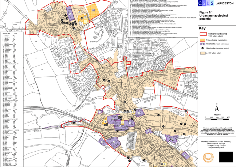
LAUNCESTON Cro ssw ay s A Field Officers Report: Part of the South Curtain Wall , Launeston Castle AB Excavations at Launceston Castle 1970-76: Interim Report (Cornish Archaeology No 16, 1977) AC Archaeological Recording at Windmill Hill, Launceston, Cornwall (1999) AD Geoghysical Survey, Ancient Monuments Laboratory, English Heritage (1993) B Archaeological Assessment and Field Evaluation of a Former Council Depot Site, Town Mills, Launceston. (1997) C Archaeological Assessment and Evaluation of Land Off Madford Lane, Launceston, Cornwall (2001) Brandon D Launceston Castle: High Tower Entrance Hillview Penrowan E The Eagle House Hotel. An Evaluation and Watching Brief 123. 4m F An Archaeological Investigation of the Keep Bethany Buildings at Launceston Castle, Cornwall OSS Vicarage, St Stephens, Launceston, Cornwall (2001) G TheCROld Marlea Cottage LANE 148.1m S f Def De H St Thomas' Priory, Launceston, Cornwall 132.9m I Field Officer's Report: Watching Brief during drainage Defworks,139.6m Eagle House Hotel, Launceston BM 141.03m 144.8m J Archaeological Recording at Eyre's Building, Castle Dyke, Launceston, Cornwall K The Fish Bone from Launceston Castle, Cornwall (Report 56/95) 1995 Cross Lanes L Medieval and Post-medieval Mammal and Bird Bones from Launceston Castle, Cornwall: 1961-1982 Excavations (Report 18/94) 1994 LB M The Classification of Slags from Launceston Castle, Cornwall N An Archaeological Investigation of the Keep Buildings at Launceston Castle, Cornwall O Archaeological Evaluation at 12 Southgate St., Launceston (Report No 96.60, Nov 1996) P Watching Brief at the Sheep Market Car Park, Launceston Q The Sheep Market Car Park, The Dockey, Launceston, Cornwall. Archaeological Evaluation R Launceston, The Dockey (Project File) S Launceston Castle (Information File) Sub Sta T Castle Hill House,El Launceston Cornwall, Report on the general structural condition (Ref 87103) Info file U Earthwork Survey at St Stephen's Launceston V Report of Geophysical Survey Site: Stie Stephens (Report 90/53, Aug 1990) W Archaeological Recording, Eagle House Annex, Launceston (Information File) Lanstephan El Sub Sta X CCRA and STCornish Buildings Group: Kensey Tannery, 1980 JOSE 'S ROAD ST JOSEPH'S RD Y Excavations at PHLaunceston Castle 1965-69: Interim Report (Cornish Archaeology No 9, 1970) Z Launceston Castle: An Interim Report (Cornish Archaeology No 3, 1964) 144.2m 12 Pero sa Castlehill 2 6 ST MARY'S ROAD 67 20 24 32 26 1 1 11 9 9 1 10 14 2 US 31 16 CLO CA 4 40 49 Y LE 3 21 35 8 18 7B 7A 19 1 55 19 E OS CL 1 10 Norman Cottages 6 SE 48a 47 48 18 7d 6 20 33 CL OS 36 1 TC Higher Cleaverfield E 7c B 34 a LB 11 19 13 24 LANE 14 ROYDON 67 14 8 L HIL M AY NE c.1907 urban extent E 38 Broad Park Sunny Bank 10 Y DU CH 42 10 38 b 9 Bdy ard CS ST EP HE N'S BM 96.79m 4 Historic site (Approximate location) OS CL 1 to 39 63 2 5 1 65 NORTH 54 44 34 1 CL OS E ROYDO N 45 35 25 11 14 59 2 AD ST Historic site (Historic extent known) 12 103.6m 1 Church of St Cuthbert Mayne 1 PLESTIN 38 RO Issues m .46 10 9 Broad Park 35 Wks St Stephens Ct 40 a IES BM 27 Kernhill 61 6 15 k tban 17 9a 3 55 45 Wes 40 g 8 ROAD IES HOLL LL HO SE CLO Archaeological Investigation # S # S El Sub Sta 13 7 nsa ROAD 11 11 Und 24 12 19 ke T re ST LEONARD'S RD ARD'S LE ON 1 1 5 3 2 17 23 17 4 1 15 1 33 8 12 Green Gables Sinks 7 29 31 Primary study area (1907 urban extent) LANSTEPHAN 43 26 ST Sentinels HOLLIES Key 2 40 g 40f RH 21 23 Truan 19 2344 13 2b ST STEPHENS 117.0m Wyndley Figure 6.1 Urban archaeological potential 11 25 Issues El Sub Sta 2 20 7b 2 FIEL D 2 16 28 17 1 AD 27 27a 7a 6 18 PR IN 18 .8m 76 20 CE 10 PH IL B 32 2 o tts IP RO A 1 1 t ou Sp PRIN CE CH ARLE S CL OSE 77.7m .9 0m BM 73 54 3 21 m RH 0. 91 W ins o rC 18 OS E CL RO Gardens El Sub Sta 25 2 7 8 15 1a 4 8a 13 m LEA S ta Allotment Tregaron 10 CU TH BE RT 1 6 28 .6 3 H RC ON TS DU Villas 1 TCB Pendora Boslowan Holland Horwell 13 16 11 ST 6a 18 8 12 81 U CH 12 8 2 BM 7 10 Castle View NEWPORT ks Sin 12 3 82.6m St Joseph's Sch b Su El BM 93.77m 1 14 64 28 a Sarnia 1a 7 30 55 8 38 A DUTSON ROAD BM 99.10m 1 32 44 Trelawny 13 32a Chamdene 103.6m LB 95.7m ER A 388 85.6m 82.9m 5 3 South V CLEA LOWER gale Nightin e Cottag "S# ! ! "S# 14 1 9 7 8 Midway 14 7 s 3 Issue 6 m 88.1 34 PW s Mill 1 14 h Bus 1 13 17 Sun Sch 1 57 7 Pump (disused) 12 2736 15 Sinks LB 12 1737 16 13 1 15 1 3 2 Factory 6 ck Tra 6 54 1 13 32 9m 9.5 M6 5 B B 9 26 T OR WP NE UA RE SQ 19 Inn Wks " ! 3 1515 #0 5S Foxfield s Work 10 5 .6m 68 Broad Meadows 30 14 7 Well 7 75.3m St ore Cross RD Abattoir (remains of) 1 43 39 35 31 29 23 1 2 Mil l Ea st 47 33 4 1 to No 3 to rth 18 P la ga c e te 1 Isa le 42a 19 4 to 21 6 Ha ll " ! 4 Graveyard RO AD 15 AL K Car Park CASTLE 6 STRE ET 4 PC El Sub Sta P's Moor Villa 3 6m 1 to 15 1 1 27 13 BM 113 .9 9 2 ne 8 3 13 STR EET W Car Park 3 17 9 1 e 11 MAS ROA 11a PARK ROA D PRIORY 6 to To M wn Flaills ts Co un TOW Ya cil N rd MIL LS ge Ga ra 9 45 16 20 ST THO 1 ASTL E DO CK AC RE PW No rth Ca g s tl ate Ch e S Str ap tre eet et el 11 36 TH E 4 WE ST 2 D 23 8 "S# g ! %T to Marwellyn 26 45 8 7 11 4 5 12 e ay nm er W ER ET RE ST House (Museum) 38 Allotment Gardens TO TCB 12 LB Lawrence A BM 95.62m y 37 4a rth No PH Pengardn Bd "S# ! 32 56m 102. Bridgend Guide Post 91.7m CR 2 8 97 El Sub Sta 2 D OA AR 88 OD A3 BM ard 84 79.9m WO D W "S#S# ! " ! 2 2 12 1 Maiden's Well (site of) Slu ice 8 1 A RO 1 to 3 4 Priory Cottages A OD O W 8 38 A 16 to w Ne 12 5a El Sub Sta Rise 40 to 50 100.9m 2 16 L Chapel CR 12 5 7a Sluice 6976 FW 2 33 Playground Ivydale 400 Historic Environment Service (Projects) Environment & Heritage Cornwall County Council hes@cornwall.gov.uk 5 to HIL L 9 Brook House CATHE RINE'S HIL 63 6 8 1-4 AS oth 300 All material copyright © Cornwall County Council 2005 Based upon the Ordnance Survey 1:10000 and Landline mapping with the permission of the controller of Her Majesty's Stationery Office © Crown Copyright. Unauthorised reproduction infringes Crown Copyright and may lead to prosecution or civil proceedings. CCC licence No 100019590. 12a 7 1 43A 32 SR 53 33 Ke ns ey BR ID 3 6 51 2 3 hob Re ks Wor 10 18 6 26 30 Depository to TH OM 200 7 L HIL n ow wsd se Bo Hou LA NE 20 ST metres 25 AS G O DA " ! The Flat 22 18 O Sieda 25 W Priory Mere Y DR UN NS FO DE AR Elan Michel Playing Field 40 6 5 M THO Pond 13 7 ROAD 100 WB "S# ! Southern Court 42 " ! Sinks S EN RD GA " ! 5 AN Y DR rg 6 Ground 30 Old da Woo ge s Cotta 77.1m Trac k 3473 " ! # S 106 ST TREDYD N FOU Fo 7 Burial 46 1 da " ! 4m 0 105 48 2 14 21 3976 " ! 36 8 24 W oo D 5 77.2 40 1 BM 42 2 STA 75.6m OA NR TIO 102 # S 103 STATION ROAD use ria Ho Victo 62Steam Railway 6 Treloar Terrace 18 96.6m Y LANE PRIOR Sl Issues Weir "S# ! "S# ! El Sub Sta 44 ST THOMAS 6293 El Sub Sta Launceston Station Launceston 4093 5390 Store (site of) 88 5192 4794 1993 Bakery Chapel BM 74 .34m FIELD Club 1 78.9m Store PH A3 78.0m 95 30 2 46 21 BM 77.0 9m Remains of Priory Bakery Industrial Estate 48 77.4m Def 78.3m RIVERSIDE 81.1m 33 Sl Newport Industrial Estate 88 A3 SD BM 78.37m FF CR 4 tts l Co pbel Cam (Augustinian founded 1127) 69.8m 104 Newport "S# ! 90 50 LANE ED and Ward Bdy SR PO 1 .5m 69 SR Drain UNDER " ! ! " 6 0.91m RH LB D 0.91m RH 1800 " ! #6 9S FW Hall 3 132 53 0 ST2THOMAS St Thomas the Apostle's Church 58 Ward Bdy SR Leat 0.91m RH 67.7m er K ense y "S# ! 3 Water Sinks 58a 3200 1800 9 1 92 SR MA HO y d Bd W ar 34 Bridge T ST BM 79.42m 0.91m RH Def Trevellan (dis) b Clu 1m RH De f Weir 64.5m E RIVERSID BM 68.03m Garage Aqueduct (dis) Bridge Willow Cotts 2 Rainb ows End 1 0.9 1 CS St Thomas's Green Riv 1 1 Bowling m .03 68 Railw ay N "S# ! ! "S# g " ! %X!"S# !" ""SS## "S#! "S# ! ! " ! ! B H g%!"S#!"S# % g " ! # S "9 3 ! "S# ! Bywater er Riv BM Und Ste am 7 ston e rag Ga e rag Ga GE R OA D 3a 1 s PC Launce TCB 1 1m 27 Field End 2356 2 38 2a Trehayes Stephenhaye 0.9 1 41 11 St Stephens County Primary School Underhayes dW 86 ROYDON ROAD 42 Half Acre an ED De f 12 rth Lana LANE UNDERHAYES Hill Barn Def y 1m 0.9 9946 40 26 46 0060 1 Tannery PM 2 Gas Works 19 3 Tannery 0658 18 4 Cemetery PM 5 Foundry 19 6 Leat 17 7 Cemeteryf PM De 8 Livestock Market PM 9 Cemetery MD 10 Cemetery MD 11 Reservoir PM 12 Police Station RH C19 13 Workhouse 19 14 Brewery PM 15 Guildhall 17 0048 16 Quarry PM 17 Quarry PM 18 Quarry PM 19 Quarry PM 20 Graveyard PM 21 Quarry PM 22 Quarry PM 23 Public House PM 24 Blacksmith's Workshop PM 25 Quarry PM 26 Cross MD 27 Pound PM 28 Almshouse PM 29 Religious House MD 30 Chapel MD 31 Cross MD 32 Cross MD 33 Chapel MD 34 Fulling Mill PM 35 Cemetery MD 36 PM 0032 Sunday School 37 School PM 38 School PM 39 Cottage Hospital PM 40 School PM 41 Cross MD 42 Fountain PM 43 Drinking fountain PM 44 Religious House PM 45 Chapel MD 46 Cross MD 47 Headstone C19 48 Tomb C19 49 Tomb C19 50 Telephone kiosk C20 51 Telephone kiosk C20 52 Horse Trough C19 53 Tomb C19 54 Architectural Fragment MD 55 Watering Place C19 56 Headstone C18 0014 57 Headstone C18 58 Headstone C18 59 Tomb C18 60 Tomb C18 0010 61 Water Pump C18 62 Cloister MD 63 Foundry PM 64 Almshouse MD 65 Chapel MD 66 Chapel MD 67 Findspot RB 0007 68 Cross MD 69 Architectural Fragment C17 70 Malthouse PM 71 Market PM 72 Guildhall MD Ward Bdy 0004 Def PM 73 Prison Def 74 Bridge PM Bdy Ward 75 Bridge PM Def 76 Ropewalk PM 77 Pound PM 0096 78 Manor/Settlement EM/MD 79 Windmill MD 80 Round IA/RB 81 Bastion Redoubt PM 82 Toll House PM 0092 Cross 83 MD? 84 Holywell MD/PM 85 Well80.5m PM 86 Well PM 87 Well PM 88 EM/MD 0087 Town 89 Mint EM/MD 90 Weir PM 91 Weir PM 92 Ducking Pond PM 93 Priory MD 94 Findspot MD 95 Workshop 20 96 Swimming Pool PM 97 Deer Park MD 98 Mill MD/PM 99 Chapel MD 00 Town MD 101 Horse Trough PM 102 Well PM 103 Railway Station 19 104 Goods Shed 19 105 Engine Shed 19 106 Goods Shed 19 107 Civil War Redoubt MD m Sinks 131.1m 48 Hillside 3.7 Faunwood 6 Unlur Period ays Gaz Site Type y Ch Midw Hillside 12 St Stephen's Church 254 B3 School Ho Farm 59 56 29 57 60 24 SE IDE CLO BROOKS Ga ra ge 142.6m West End Bounsalls Park 58 2b a Dow rlam 11 BM 142.95m 134.1m 4 6 WAY 1867 Trac k T DUKE STREE D OA DR OR KF B IC 1 LLS GENDA ack 6b 8 18 20 TCB 89 1 1 es us Ho 6a 142.6m Gallows Hill Gallows Hill 5.9 2m BM 13 n gio Le 52 5 1 88 35 Church Hall 2 Hadley 1 e ico mb Dinn h CH Issues Well 28 m 4.31 BM 12 tis Bri Terrace Viron 9 21 23 27 116.6m Old Vicarage 11 1 1a Duke 9 36 PO 22 Steepholme P elt er yth 5 4 141.1m Sh 6 110.6m AD ide arks w Aval ET RE ST G % g " ! # S " ! V % # g # S S " ! " ! # S "S#S# S# S#! ! U % g " "! ! #S S "! "! " ! # # S "! "S# "S# ! "! ! " Church View Fourways 8 136.6m 2 46 House weth Treno Issues Park Hill

