SIO 209 (Spring 2001)
SIO 209 (Spring 2001)
Interannual to interdecadal extratropical coupled atmosphere–ocean variability
Background notes:
Winds are nearly geostrophic (balance between Coriolis and pressure gradient force) at large scales, especially above the surface where friction is weak. They travel nearly parallel to contours of pressure or geopotential height with lows to the left in the
Northern Hemisphere. Winds are stronger when pressure/height contours are closer together. Counterclockwise flow is cyclonic and clockwise flow is anticyclonic in the
Northern Hemisphere.
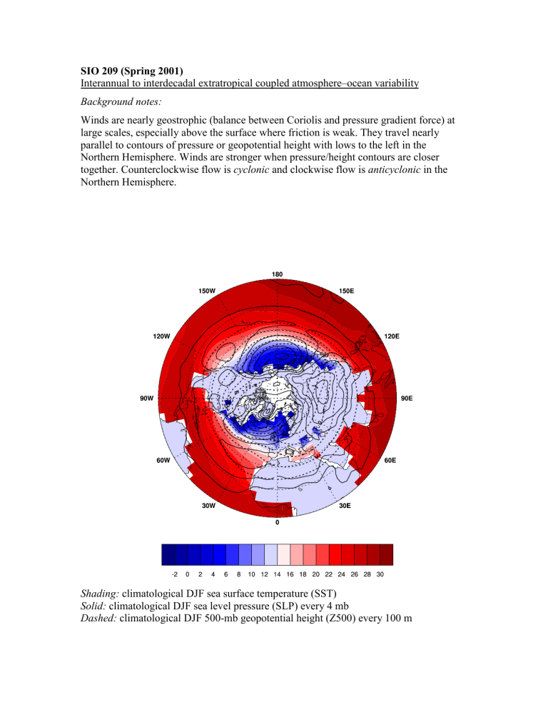
Shading: climatological DJF sea surface temperature (SST)
Solid: climatological DJF sea level pressure (SLP) every 4 mb
Dashed: climatological DJF 500-mb geopotential height (Z500) every 100 m
Climatological DJF SST pattern
Western boundary currents (Gulf Stream and Kuroshio) bring warm water to midlatitudes. These separate from eastern continental margins and create a region of strong SST gradient in western ocean basins. Interannual SST variability is greatest at the location of the climatological SST gradient.
Climatological DJF SLP pattern
Midlatitude oceans are dominated by the Aleutian and Icelandic Lows, and subtropical
Highs are weak and located in eastern subtropical ocean basins. High pressure dominates midlatitude continents.
Climatological DJF Z500 pattern
The 500-mb level occurs at about the middle of the troposphere and is the steering level for extratropical cyclones (storms). Z500 decreases poleward and has the strongest gradient at midlatitudes, which is co-located with the SST gradient and the storm track.
At midlatitudes, troughs in Z500 occur over western ocean basins and ridges occur over eastern ocean basins. Extratropical cyclones tend to be generated in western ocean basins due to the strong surface baroclinicity and land-ocean temperature contrast, travel eastward along the storm track, and decay in eastern ocean basins.
PNA pattern
The Pacific/North America (PNA) pattern is the dominant pattern of large-scale atmospheric variability over the Pacific basin and North America, occurring on time scales of several weeks to decades. It is an internal mode of the atmosphere but is responsive to tropical heating associated with ENSO. In the positive phase of the PNA, an anomalous low occurs over the central North Pacific, an anomalous high over western
Canada, and an anomalous low over the southeastern U.S. The negative phase of the
PNA is the opposite patterns of anomalous lows and highs. The climatological Z500 troughs and ridges are strengthened by positive phase PNA, whereas flow is more zonal
(west-east) with negative phase PNA.
NAO pattern
The North Atlantic Oscillation is the dominant pattern of large-scale variability over the
Atlantic basin and Europe, occurring on times scales of weeks to decades. It is an internal mode of the atmosphere, and it is currently an open question as to how responsive the
NAO is to external forcing. The Icelandic Low and Azores High are stronger in the positive phase and weaker in the negative phase of the NAO.

