A Canadian satellite mission for continuous imaging of the northern... Environment Canada, Dorval, QC Polar Communication and Weather (PCW) mission
advertisement
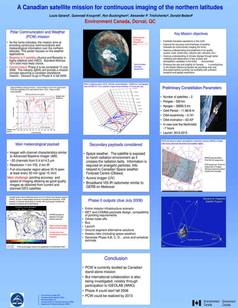
A Canadian satellite mission for continuous imaging of the northern latitudes Louis Garand1, Guennadi Kroupnik2, Ron Buckingham3, Alexander P. Trishchenko4, Donald Bedard5 Environment Canada, Dorval, QC Polar Communication and Weather (PCW) mission Key Mission objectives Meteorological Coverage Requirement _____ Goal ------------------- • As the name indicates, the mission aims at providing continuous communications and meteorological information over the northern latitudes. This poster focuses on the weather applications. • Baseline is 2 satellites (Aurora and Borealis) in highly elliptical orbit (HEO). Standard Molniya 12-h orbit most likely choice. • Current status: Phase 0 to be completed 15 July 2008. The industry (MDA) will provide a mission concept assuming a Canadian standalone mission. Decision to go in Phase A in fall 2008. Classical Molniya orbit ground track. A ground station in the north could receive PCW data regardless of its nadir position above ~55 N. Relay via GEO Is also possible. Communication Coverage requirement • Facilitate Canadian operations in the north • Improve the accuracy and timeliness of weather forecasts by continuously imaging the Arctic • Improve understanding and prediction of air quality (ozone, haze, forest fires, volcanic ash, aerosols, etc.) • Improve understanding of climate change through better modeling and observation of key surface and atmospheric variables in the Arctic environment • Enhance the role and visibility of Canada ’s contributions to the Global Observing System by providing near real time observations currently not available with sufficient temporal and spatial resolutions When mapping above 45 N, altitude varies between ~25000 km and apogee near 40,000 km. One satellite images those latitudes 14 hours per day. Preliminary Constellation Parameters Molniya orbit with 12-hr period Apogee near 40,000 km 90 • • • • • • • Number of satellites – 2 Perigee – 500 km Apogee – 39850.5 km Orbit Period – 11.9616 hr Orbit eccentricity – 0.741 Orbit inclination – 63.43º In view over the North/orbit ~7 hours • Launch: 2013-2015 Latitude [deg] 60 30 0 -30 -60 15-min intervals Perigee near -90-180 500 km -150 -120 -90 -60 -30 0 30 60 90 120 150 180 Longitude [deg] Main meteorological payload Secondary payloads considered • Imager with channel characteristics similar to Advanced Baseline Imager (ABI) • ~20 channels from 0.4 to14.5 µm • Resolution 1 km VIS, 2 km IR • Full circumpolar region above 55 N seen at least every 30 min (goal 15 min) Main challenge: pointing accuracy and speed of imaging allowing as good quality images as obtained from current and planned GEO satellites • Space weather. The satellite is exposed to harsh radiation environment as it crosses the radiation belts. Information is required on energetic particles. Info relayed to Canadian Space weather Forecast Centre (Ottawa) • Aurora imager (UV) • Broadband VIS-IR radiometer similar to GERB on Meteosat Canada hosts in Dorval (Montreal area) one of 9 Volcanic Ash Advisory Centers (VAAC). Its area of responsibility covers all of Canada and Greenland. PCW selection of channels would allow to monitor with much greater flexibility the evolution of volcanic ash concentrations. AVHRR example of detection from split window channels Higher temporal imagery Needed at high latitudes Viewing entire area simultaneously would be a big plus PCW would use 15-30 min Sequences of images, Allowing improved product Quality and coverage. Borealis • Entire mission infrastructure scenario • MET and COMMs payloads design, compatibility of pointing requirements • Orbital trade-offs • Bus • Launch • Ground segment alternative solutions • Assess risks (including space weather) • Generate Phase A,B, C, D… price and schedule estimate • PCW is currently studied as Canadian stand-alone mission • But international collaboration is also being investigated, notably through participation to IGEOLAB (WMO) • Phase A could start fall 2008 • PCW could be realized by 2013 Scenario for Integrated Satellite Program HEO LEO GEO Conclusion Environment Canada (EC) Canadian Space Agency (CSA) Northeast Space Co Canada Center for Remote Sensing (CCRS) Department of National Defense (DND) MODIS-derived AMVs From 90-min sequences Phase 0 outputs (due July 2008) PCW would largely improve the capabilities of the Montreal VAAC 1. 2. 3. 4. 5. PCW will allow to obtain atmospheric movement vectors (AMVs) at least half hourly and over the entire circumpolar region. RADARSAT CONSTELLATION Anik G1
