Operational use of AIRS Observations at the Met Office
advertisement
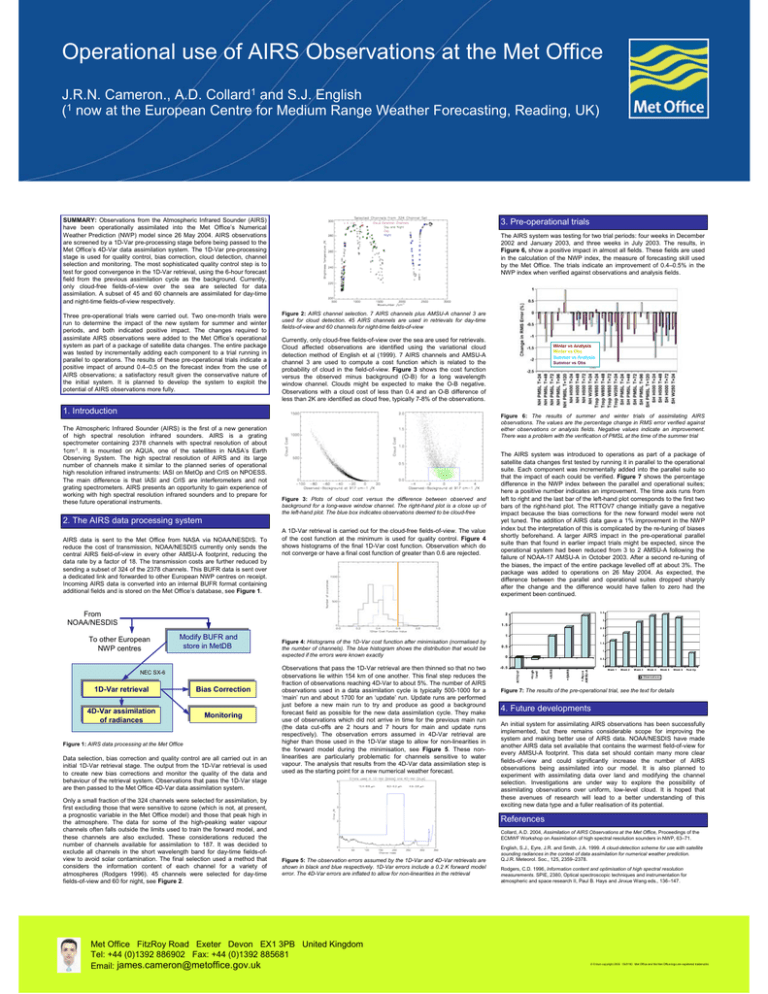
Operational use of AIRS Observations at the Met Office J.R.N. Cameron., A.D. Collard1 and S.J. English (1 now at the European Centre for Medium Range Weather Forecasting, Reading, UK) SUMMARY: Observations from the Atmospheric Infrared Sounder (AIRS) have been operationally assimilated into the Met Office’s Numerical Weather Prediction (NWP) model since 26 May 2004. AIRS observations are screened by a 1D-Var pre-processing stage before being passed to the Met Office’s 4D-Var data assimilation system. The 1D-Var pre-processing stage is used for quality control, bias correction, cloud detection, channel selection and monitoring. The most sophisticated quality control step is to test for good convergence in the 1D-Var retrieval, using the 6-hour forecast field from the previous assimilation cycle as the background. Currently, only cloud-free fields-of-view over the sea are selected for data assimilation. A subset of 45 and 60 channels are assimilated for day-time and night-time fields-of-view respectively. Three pre-operational trials were carried out. Two one-month trials were run to determine the impact of the new system for summer and winter periods, and both indicated positive impact. The changes required to assimilate AIRS observations were added to the Met Office’s operational system as part of a package of satellite data changes. The entire package was tested by incrementally adding each component to a trial running in parallel to operations. The results of these pre-operational trials indicate a positive impact of around 0.4–0.5 on the forecast index from the use of AIRS observations; a satisfactory result given the conservative nature of the initial system. It is planned to develop the system to exploit the potential of AIRS observations more fully. 3. Pre-operational trials The AIRS system was testing for two trial periods: four weeks in December 2002 and January 2003, and three weeks in July 2003. The results, in Figure 6, show a positive impact in almost all fields. These fields are used in the calculation of the NWP index, the measure of forecasting skill used by the Met Office. The trials indicate an improvement of 0.4–0.5% in the NWP index when verified against observations and analysis fields. Figure 2: AIRS channel selection. 7 AIRS channels plus AMSU-A channel 3 are used for cloud detection. 45 AIRS channels are used in retrievals for day-time fields-of-view and 60 channels for night-time fields-of-view Currently, only cloud-free fields-of-view over the sea are used for retrievals. Cloud affected observations are identified using the variational cloud detection method of English et al (1999). 7 AIRS channels and AMSU-A channel 3 are used to compute a cost function which is related to the probability of cloud in the field-of-view. Figure 3 shows the cost function versus the observed minus background (O-B) for a long wavelength window channel. Clouds might be expected to make the O-B negative. Observations with a cloud cost of less than 0.4 and an O-B difference of less than 2K are identified as cloud free, typically 7-8% of the observations. 1. Introduction The Atmospheric Infrared Sounder (AIRS) is the first of a new generation of high spectral resolution infrared sounders. AIRS is a grating spectrometer containing 2378 channels with spectral resolution of about 1cm-1. It is mounted on AQUA, one of the satellites in NASA’s Earth Observing System. The high spectral resolution of AIRS and its large number of channels make it similar to the planned series of operational high resolution infrared instruments: IASI on MetOp and CrIS on NPOESS. The main difference is that IASI and CrIS are interferometers and not grating spectrometers. AIRS presents an opportunity to gain experience of working with high spectral resolution infrared sounders and to prepare for these future operational instruments. Figure 6: The results of summer and winter trials of assimilating AIRS observations. The values are the percentage change in RMS error verified against either observations or analysis fields. Negative values indicate an improvement. There was a problem with the verification of PMSL at the time of the summer trial Figure 3: Plots of cloud cost versus the difference between observed and background for a long-wave window channel. The right-hand plot is a close up of the left-hand plot. The blue box indicates observations deemed to be cloud-free 2. The AIRS data processing system AIRS data is sent to the Met Office from NASA via NOAA/NESDIS. To reduce the cost of transmission, NOAA/NESDIS currently only sends the central AIRS field-of-view in every other AMSU-A footprint, reducing the data rate by a factor of 18. The transmission costs are further reduced by sending a subset of 324 of the 2378 channels. This BUFR data is sent over a dedicated link and forwarded to other European NWP centres on receipt. Incoming AIRS data is converted into an internal BUFR format containing additional fields and is stored on the Met Office’s database, see Figure 1. Winter vs Analysis Winter vs Obs Summer vs Analysis Summer vs Obs A 1D-Var retrieval is carried out for the cloud-free fields-of-view. The value of the cost function at the minimum is used for quality control. Figure 4 shows histograms of the final 1D-Var cost function. Observation which do not converge or have a final cost function of greater than 0.6 are rejected. From NOAA/NESDIS The AIRS system was introduced to operations as part of a package of satellite data changes first tested by running it in parallel to the operational suite. Each component was incrementally added into the parallel suite so that the impact of each could be verified. Figure 7 shows the percentage difference in the NWP index between the parallel and operational suites; here a positive number indicates an improvement. The time axis runs from left to right and the last bar of the left-hand plot corresponds to the first two bars of the right-hand plot. The RTTOV7 change initially gave a negative impact because the bias corrections for the new forward model were not yet tuned. The addition of AIRS data gave a 1% improvement in the NWP index but the interpretation of this is complicated by the re-tuning of biases shortly beforehand. A larger AIRS impact in the pre-operational parallel suite than that found in earlier impact trials might be expected, since the operational system had been reduced from 3 to 2 AMSU-A following the failure of NOAA-17 AMSU-A in October 2003. After a second re-tuning of the biases, the impact of the entire package levelled off at about 3%. The package was added to operations on 26 May 2004. As expected, the difference between the parallel and operational suites dropped sharply after the change and the difference would have fallen to zero had the experiment been continued. 3 .5 2 3 1 .5 2 .5 1D-Var 1D-Varretrieval retrieval 4D-Var 4D-Varassimilation assimilation of of radiances radiances Bias BiasCorrection Correction Monitoring Monitoring Figure 1: AIRS data processing at the Met Office Data selection, bias correction and quality control are all carried out in an initial 1D-Var retrieval stage. The output from the 1D-Var retrieval is used to create new bias corrections and monitor the quality of the data and behaviour of the retrieval system. Observations that pass the 1D-Var stage are then passed to the Met Office 4D-Var data assimilation system. Only a small fraction of the 324 channels were selected for assimilation, by first excluding those that were sensitive to ozone (which is not, at present, a prognostic variable in the Met Office model) and those that peak high in the atmosphere. The data for some of the high-peaking water vapour channels often falls outside the limits used to train the forward model, and these channels are also excluded. These considerations reduced the number of channels available for assimilation to 187. It was decided to exclude all channels in the short wavelength band for day-time fields-ofview to avoid solar contamination. The final selection used a method that considers the information content of each channel for a variety of atmospheres (Rodgers 1996). 45 channels were selected for day-time fields-of-view and 60 for night, see Figure 2. 1 0 0 .5 0 W eek 1 + Aqua AM SU-A -0 .5 + AI RS Observations that pass the 1D-Var retrieval are then thinned so that no two observations lie within 154 km of one another. This final step reduces the fraction of observations reaching 4D-Var to about 5%. The number of AIRS observations used in a data assimilation cycle is typically 500-1000 for a ‘main’ run and about 1700 for an ‘update’ run. Update runs are performed just before a new main run to try and produce as good a background forecast field as possible for the new data assimilation cycle. They make use of observations which did not arrive in time for the previous main run (the data cut-offs are 2 hours and 7 hours for main and update runs respectively). The observation errors assumed in 4D-Var retrieval are higher than those used in the 1D-Var stage to allow for non-linearities in the forward model during the minimisation, see Figure 5. These nonlinearities are particularly problematic for channels sensitive to water vapour. The analysis that results from the 4D-Var data assimilation step is used as the starting point for a new numerical weather forecast. 2 1 .5 0 .5 +EARS NEC SX-6 Figure 4: Histograms of the 1D-Var cost function after minimisation (normalised by the number of channels). The blue histogram shows the distribution that would be expected if the errors were known exactly + hi gh land Modify ModifyBUFR BUFR and and store store in in MetDB MetDB RTTOV7 To other European NWP centres 1 W eek 2 W eek 3 W eek 4 W eek 5 W eek 6 Post Op v Observat ions Figure 7: The results of the pre-operational trial, see the text for details 4. Future developments An initial system for assimilating AIRS observations has been successfully implemented, but there remains considerable scope for improving the system and making better use of AIRS data. NOAA/NESDIS have made another AIRS data set available that contains the warmest field-of-view for every AMSU-A footprint. This data set should contain many more clear fields-of-view and could significantly increase the number of AIRS observations being assimilated into our model. It is also planned to experiment with assimilating data over land and modifying the channel selection. Investigations are under way to explore the possibility of assimilating observations over uniform, low-level cloud. It is hoped that these avenues of research will lead to a better understanding of this exciting new data type and a fuller realisation of its potential. References Collard, A.D. 2004, Assimilation of AIRS Observations at the Met Office, Proceedings of the ECMWF Workshop on Assimilation of high spectral resolution sounders in NWP, 63–71. Figure 5: The observation errors assumed by the 1D-Var and 4D-Var retrievals are shown in black and blue respectively. 1D-Var errors include a 0.2 K forward model error. The 4D-Var errors are inflated to allow for non-linearities in the retrieval Met Office FitzRoy Road Exeter Devon EX1 3PB United Kingdom Tel: +44 (0)1392 886902 Fax: +44 (0)1392 885681 Email: james.cameron@metoffice.gov.uk English, S.J., Eyre, J.R. and Smith, J.A. 1999. A cloud-detection scheme for use with satellite sounding radiances in the context of data assimilation for numerical weather prediction. Q.J.R. Meteorol. Soc., 125, 2359–2378. Rodgers, C.D. 1996, Information content and optimisation of high spectral resolution measurements. SPIE, 2380, Optical spectroscopic techniques and instrumentation for atmospheric and space research II, Paul B. Hays and Jinxue Wang eds., 136–147. © Crown copyright 2005 05/0190 Met Office and the Met Office logo are registered trademarks
