Part V: Terrestrial land mobile data
advertisement
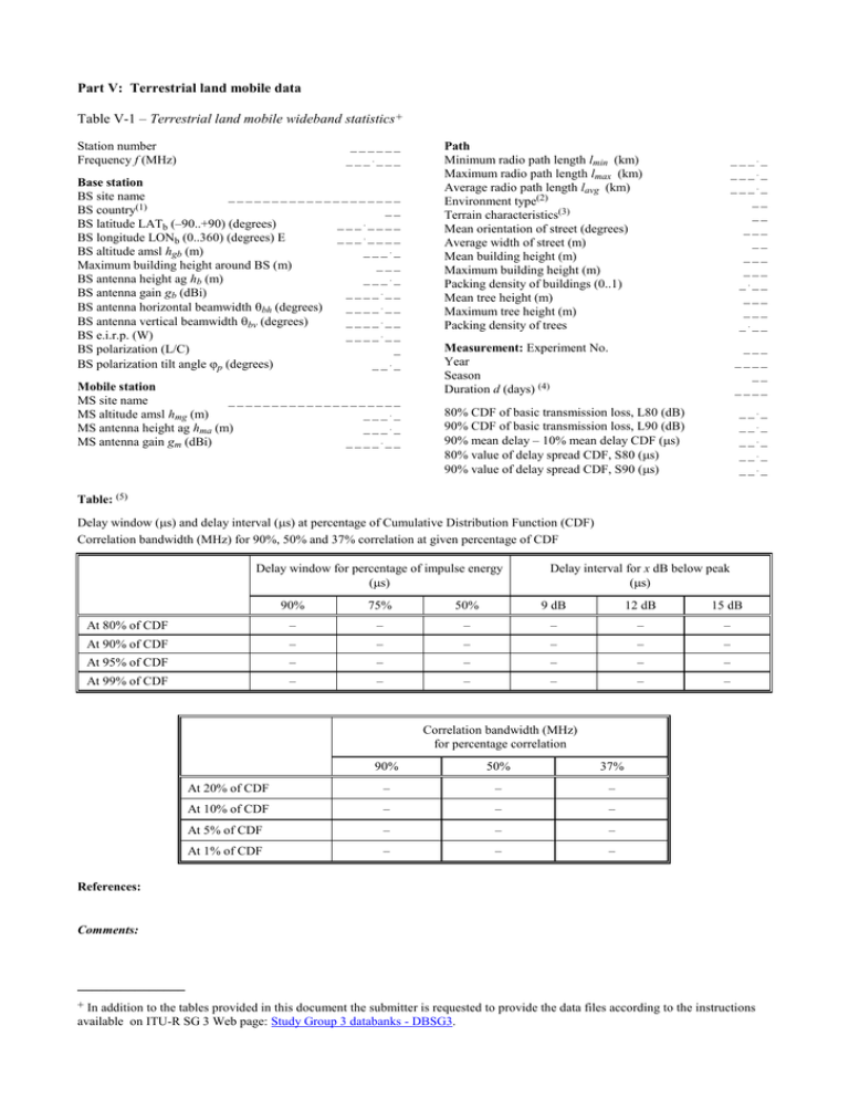
Part V: Terrestrial land mobile data Table V-1 – Terrestrial land mobile wideband statistics+ Station number Frequency f (MHz) ______ ______ Base station BS site name ____________________ BS country(1) __ BS latitude LATb (–90..+90) (degrees) _______ BS longitude LONb (0..360) (degrees) E _______ BS altitude amsl hgb (m) ____ Maximum building height around BS (m) ___ BS antenna height ag hb (m) ____ BS antenna gain gb (dBi) ______ BS antenna horizontal beamwidth bh (degrees) ______ BS antenna vertical beamwidth bv (degrees) ______ BS e.i.r.p. (W) ______ BS polarization (L/C) _ BS polarization tilt angle p (degrees) ___ Mobile station MS site name ____________________ MS altitude amsl hmg (m) ____ MS antenna height ag hma (m) ____ MS antenna gain gm (dBi) ______ Path Minimum radio path length lmin (km) Maximum radio path length lmax (km) Average radio path length lavg (km) Environment type(2) Terrain characteristics(3) Mean orientation of street (degrees) Average width of street (m) Mean building height (m) Maximum building height (m) Packing density of buildings (0..1) Mean tree height (m) Maximum tree height (m) Packing density of trees ____ ____ ____ __ __ ___ __ ___ ___ ___ ___ ___ ___ Measurement: Experiment No. Year Season Duration d (days) (4) ___ ____ __ ____ 80% CDF of basic transmission loss, L80 (dB) 90% CDF of basic transmission loss, L90 (dB) 90% mean delay – 10% mean delay CDF (s) 80% value of delay spread CDF, S80 (s) 90% value of delay spread CDF, S90 (s) ___ ___ ___ ___ ___ Table: (5) Delay window (s) and delay interval (s) at percentage of Cumulative Distribution Function (CDF) Correlation bandwidth (MHz) for 90%, 50% and 37% correlation at given percentage of CDF Delay window for percentage of impulse energy (s) Delay interval for x dB below peak (s) 90% 75% 50% 9 dB 12 dB 15 dB At 80% of CDF – – – – – – At 90% of CDF – – – – – – At 95% of CDF – – – – – – At 99% of CDF – – – – – – Correlation bandwidth (MHz) for percentage correlation 90% 50% 37% At 20% of CDF – – – At 10% of CDF – – – At 5% of CDF – – – At 1% of CDF – – – References: Comments: _______________ + In addition to the tables provided in this document the submitter is requested to provide the data files according to the instructions available on ITU-R SG 3 Web page: Study Group 3 databanks - DBSG3. (1) Use ISO 3166-1 alpha-2 country codes.. (2) See Annex 3 for environment types. Measurements should only cover one type of environment. (3) Terrain characteristics can be given as: FL: flat, HI: hilly, MO: mountainous. (4) Duration is the total time of valid measurements for this dataset, expressed as a real number (e.g. 339.888 days). (5) Submissions should comply with the acceptance criteria specified in Rec. ITU-R P.311.
