SATELLITE SIGNATURES ASSOCIATED WITH SIGNIFICANT CONVECTIVELY-INDUCED TURBULENCE EVENTS Kristopher
advertisement
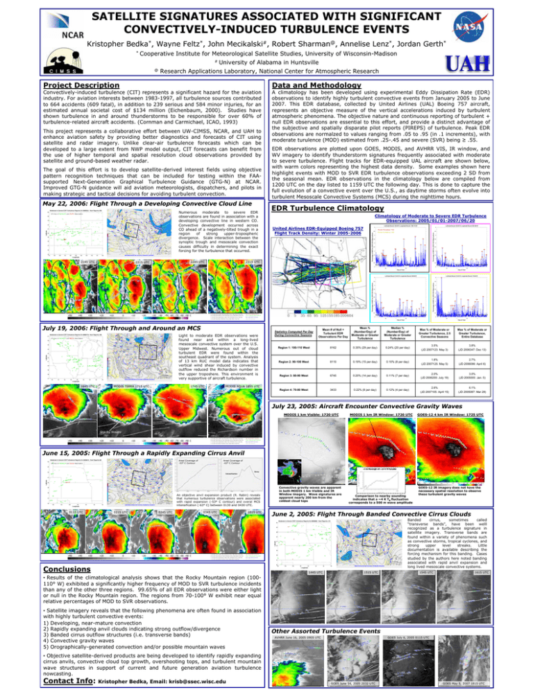
SATELLITE SIGNATURES ASSOCIATED WITH SIGNIFICANT CONVECTIVELY-INDUCED TURBULENCE EVENTS Kristopher Bedka*, Wayne Feltz*, John Mecikalski#, Robert Sharman@, Annelise Lenz*, Jordan Gerth* * Cooperative Institute for Meteorological Satellite Studies, University of Wisconsin-Madison # @ University of Alabama in Huntsville Research Applications Laboratory, National Center for Atmospheric Research Project Description Convectively-induced turbulence (CIT) represents a significant hazard for the aviation industry. For aviation interests between 1983-1997, all turbulence sources contributed to 664 accidents (609 fatal), in addition to 239 serious and 584 minor injuries, for an estimated annual societal cost of $134 million (Eichenbaum, 2000). Studies have shown turbulence in and around thunderstorms to be responsible for over 60% of turbulence-related aircraft accidents. (Cornman and Carmichael, ICAO, 1993) This project represents a collaborative effort between UW-CIMSS, NCAR, and UAH to enhance aviation safety by providing better diagnostics and forecasts of CIT using satellite and radar imagery. Unlike clear-air turbulence forecasts which can be developed to a large extent from NWP model output, CIT forecasts can benefit from the use of higher temporal and spatial resolution cloud observations provided by satellite and ground-based weather radar. The goal of this effort is to develop satellite-derived interest fields using objective pattern recognition techniques that can be included for testing within the FAAsupported Next-Generation Graphical Turbulence Guidance (GTG-N) at NCAR. Improved GTG-N guidance will aid aviation meteorologists, dispatchers, and pilots in making strategic and tactical decisions for avoiding turbulent convection. May 22, 2006: Flight Through a Developing Convective Cloud Line Numerous moderate to severe EDR observations are found in association with a developing convective line in western CO. Convective development occurred across CO ahead of a negatively-tilted trough in a region of strong upper-tropospheric divergence. Scale interaction between the synoptic trough and mesoscale convection causes difficulty in determining the exact forcing for the turbulence that occurred. UTC Hour of MODERATE and SEVERE Observations 2145 UTC 2245 UTC 2215 UTC 1645 UTC A: Aircraft Temp Colder Than IR Window Temp, Flight Above Cloud Top Red: Severe EDR Turbulence B: Aircraft Temp Warmer Than IR Window Temp, Flight Below Cloud Top Green: Moderate EDR Turbulence C: Aircraft Temp Significantly Colder Than IR Window Temp, Clear Sky Blue: Light EDR Turbulence I: Aircraft Temp Near IR Window Temp, Flight Within Cloud Top Grey: No Turbulence Light to moderate EDR observations were found near and within a long-lived mesoscale convective system over the U.S. Upper Midwest. Numerous out of cloud turbulent EDR were found within the southeast quadrant of the system. Analysis of 13 km RUC model data indicates that vertical wind shear induced by convective outflow reduced the Richardson number in the upper troposhere. This environment is very supportive of aircraft turbulence. 1745 UTC MODIS TERRA 1715 UTC EDR observations are plotted upon GOES, MODIS, and AVHRR VIS, IR window, and WV imagery to identify thunderstorm signatures frequently associated with moderate to severe turbulence. Flight tracks for EDR-equipped UAL aircraft are shown below, with warm colors representing the highest data density. Some examples shown here highlight events with MOD to SVR EDR turbulence observations exceeding 2 SD from the seasonal mean. EDR observations in the climatology below are compiled from 1200 UTC on the day listed to 1159 UTC the following day. This is done to capture the full evolution of a convective event over the U.S., as daytime storms often evolve into turbulent Mesoscale Convective Systems (MCS) during the nighttime hours. EDR Turbulence Climatology Climatology of Moderate to Severe EDR Turbulence Observations: 2005/01/01-2007/06/20 United Airlines EDR-Equipped Boeing 757 Flight Track Density: Winter 2005-2006 Events Exceeding 3 SD Events Exceeding 2 SD 2315 UTC July 19, 2006: Flight Through and Around an MCS UTC Hour of MODERATE and SEVERE Observations Data and Methodology A climatology has been developed using experimental Eddy Dissipation Rate (EDR) observations to identify highly turbulent convective events from January 2005 to June 2007. This EDR database, collected by United Airlines (UAL) Boeing 757 aircraft, represents an objective measure of the vertical accelerations induced by turbulent atmospheric phenomena. The objective nature and continuous reporting of turbulent + null EDR observations are essential to this effort, and provide a distinct advantage of the subjective and spatially disparate pilot reports (PIREPS) of turbulence. Peak EDR observations are normalzed to values ranging from .05 to .95 (in .1 increments), with moderate turulence (MOD) estimated from .25-.45 and severe (SVR) being ≥ .55. Statistics Computed Per Day During Convective Seasons Mean # of Null + Turbulent EDR Observations Per Day Mean % (Number/Day) of Moderate or Greater Turbulence Median % (Number/Day) of Moderate or Greater Turbulence Max % of Moderate or Greater Turbulence, 2.5 Convective Seasons Max % of Moderate or Greater Turbulence, Entire Database Region 1: 100-110 West 8162 0.35% (29 per day) 0.24% (20 per day) 3.5% (JD 2007123: May 3) 3.8% (JD 2006347: Dec 13) Region 2: 90-100 West 8110 0.19% (15 per day) 0.10% (8 per day) 1.8% (JD 2007125: May 5) 2.7% (JD 2006096: April 6) Region 3: 80-90 West 6745 0.20% (14 per day) 0.11% (7 per day) 2.0% (JD 2006200: July 19) 3.0% (JD 2005005: Jan. 5) Region 4: 70-80 West 3433 0.22% (8 per day) 0.12% (4 per day) 2.6% (JD 2007105: April 15) 6.1% (JD 2005087: Mar 28) MODIS AQUA 1855 UTC July 23, 2005: Aircraft Encounter Convective Gravity Waves MODIS 1 km Visible: 1720 UTC MODIS 1 km IR Window: 1720 UTC GOES-12 4 km IR Window: 1725 UTC Gravity Waves A: Aircraft Temp Colder Than IR Window Temp, Flight Above Cloud Top Red: Severe EDR Turbulence B: Aircraft Temp Warmer Than IR Window Temp, Flight Below Cloud Top Green: Moderate EDR Turbulence C: Aircraft Temp Significantly Colder Than IR Window Temp, Clear Sky Blue: Light EDR Turbulence I: Aircraft Temp Near IR Window Temp, Flight Within Cloud Top Grey: No Turbulence June 15, 2005: Flight Through a Rapidly Expanding Cirrus Anvil Areal Coverage of -53° C Contour UTC Hour of MODERATE and SEVERE Observations Areal Coverage of -63° C Contour ~5 km Wavelength with ~2-4 K TB Fluctuation Decay Intensification An objective anvil expansion product (R. Rabin) reveals that numerous turbulence observations were associated with rapid expansion (-53º C contour) and overal MCS intensification (-63° C) between 0130 and 0430 UTC. 0115 UTC 0215 UTC 0245 UTC 0345 UTC 0515 UTC A: Aircraft Temp Colder Than IR Window Temp, Flight Above Cloud Top Red: Severe EDR Turbulence B: Aircraft Temp Warmer Than IR Window Temp, Flight Below Cloud Top Green: Moderate EDR Turbulence C: Aircraft Temp Significantly Colder Than IR Window Temp, Clear Sky Blue: Light EDR Turbulence I: Aircraft Temp Near IR Window Temp, Flight Within Cloud Top Grey: No Turbulence Conclusions Convective gravity waves are apparent in both MODIS 1 km Visible and IR Window imagery. Wave signatures are apparent nearly 200 km from the coldest cloud tops Comparison to nearby sounding indicates that a ~4 K TB fluctuation corresponds to a 500 m wave amplitude GOES-12 IR imagery does not have the necessary spatial resolution to observe these turbulent gravity waves June 2, 2005: Flight Through Banded Convective Cirrus Clouds Banded cirrus, sometimes called “transverse bands”, have been welll recognized as a turbulence signature in satellite imagery. Transverse bands are found within a variety of phenomena such as convective storms, tropical cyclones, and strong upper level streaks. Little documentation is available describing the forcing mechanism for this banding. Cases studied by the authors here noted banding associated with rapid anvil expansion and long lived mesoscale convective systems. 1445 UTC 1515 UTC 1545 UTC 1615 UTC • Results of the climatological analysis shows that the Rocky Mountain region (100110° W) exhibited a significantly higher frequency of MOD to SVR turbulence incidents than any of the other three regions. 99.65% of all EDR observations were either light or null in the Rocky Mountain region. The regions from 70-100° W exhibit near equal relative percentages of MOD to SVR observations. • Satellite imagery reveals that the following phenomena are often found in association with highly turbulent convective events: 1) Developing, near-mature convection 2) Rapidly expanding anvil clouds indicating strong outflow/divergence 3) Banded cirrus outflow structures (i.e. transverse bands) 4) Convective gravity waves 5) Orographically-generated convection and/or possible mountain waves Other Assorted Turbulence Events AVHRR June 16, 2005 0905 UTC GOES July 6, 2005 0115 UTC • Objective satellite-derived products are being developed to identify rapidly expanding cirrus anvils, convective cloud top growth, overshooting tops, and turbulent mountain wave structures in support of current and future generation aviation turbulence nowcasting. Contact Info: Kristopher Bedka, Email: krisb@ssec.wisc.edu GOES June 16, 2005 2032 UTC GOES May 5, 2007 1815 UTC
