C P
advertisement
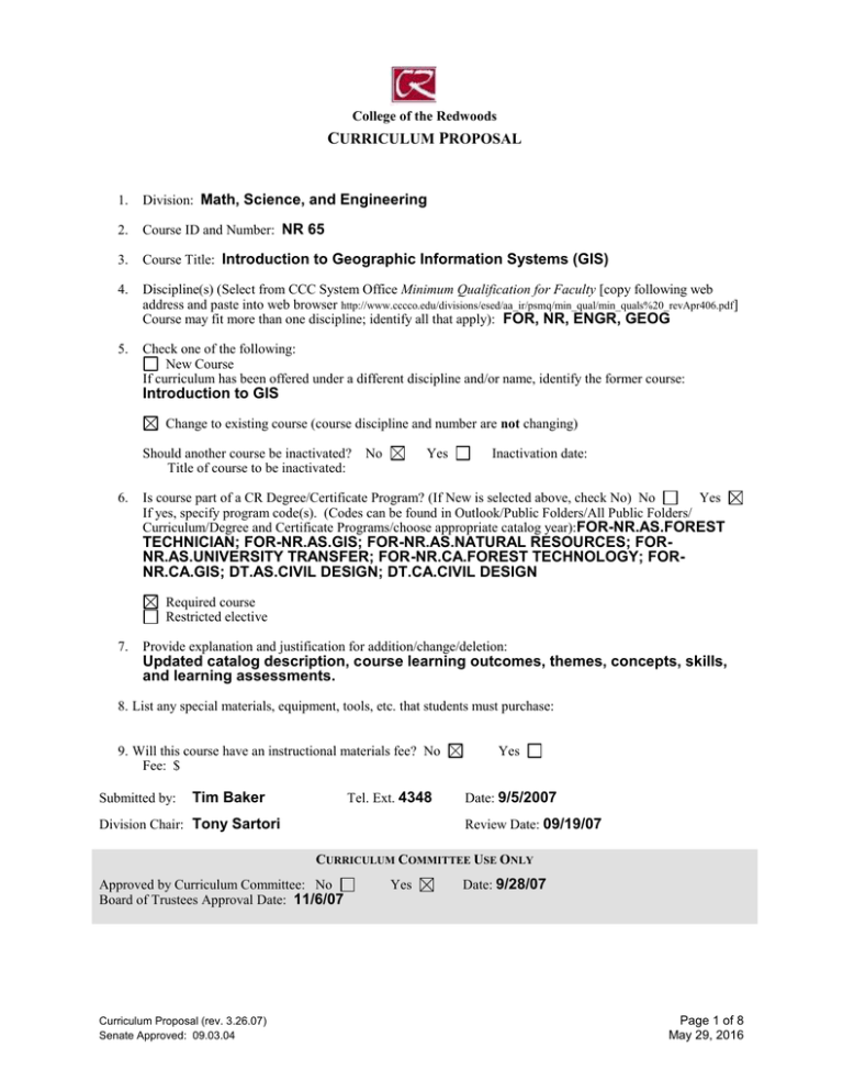
College of the Redwoods CURRICULUM PROPOSAL 1. Division: Math, Science, and Engineering 2. Course ID and Number: NR 65 3. Course Title: Introduction to Geographic Information Systems (GIS) 4. Discipline(s) (Select from CCC System Office Minimum Qualification for Faculty [copy following web address and paste into web browser http://www.cccco.edu/divisions/esed/aa_ir/psmq/min_qual/min_quals%20_revApr406.pdf] Course may fit more than one discipline; identify all that apply): FOR, NR, ENGR, GEOG 5. Check one of the following: New Course If curriculum has been offered under a different discipline and/or name, identify the former course: Introduction to GIS Change to existing course (course discipline and number are not changing) Should another course be inactivated? Title of course to be inactivated: 6. No Yes Inactivation date: Is course part of a CR Degree/Certificate Program? (If New is selected above, check No) No Yes If yes, specify program code(s). (Codes can be found in Outlook/Public Folders/All Public Folders/ Curriculum/Degree and Certificate Programs/choose appropriate catalog year):FOR-NR.AS.FOREST TECHNICIAN; FOR-NR.AS.GIS; FOR-NR.AS.NATURAL RESOURCES; FORNR.AS.UNIVERSITY TRANSFER; FOR-NR.CA.FOREST TECHNOLOGY; FORNR.CA.GIS; DT.AS.CIVIL DESIGN; DT.CA.CIVIL DESIGN Required course Restricted elective 7. Provide explanation and justification for addition/change/deletion: Updated catalog description, course learning outcomes, themes, concepts, skills, and learning assessments. 8. List any special materials, equipment, tools, etc. that students must purchase: 9. Will this course have an instructional materials fee? No Fee: $ Submitted by: Tim Baker Tel. Ext. 4348 Division Chair: Tony Sartori Yes Date: 9/5/2007 Review Date: 09/19/07 CURRICULUM COMMITTEE USE ONLY Approved by Curriculum Committee: No Board of Trustees Approval Date: 11/6/07 Curriculum Proposal (rev. 3.26.07) Senate Approved: 09.03.04 Yes Date: 9/28/07 Page 1 of 8 May 29, 2016 SUMMARY OF CURRICULUM CHANGES FOR AN EXISTING COURSE FEATURES Catalog Description (Please include complete text of old and new catalog descriptions.) Grading Standard OLD NEW An introduction to the use of Geographic Information Systems software to produce a database of digitized and inventory information that can be used to create computer generated maps, charts, and graphs showing relationships between different variables in the database. The course will focus on natural resource data and mapping, and will utilize the ESRI ArcView software. Students will learn how to operate the software, to input data into the computer using digitizing tablets, and to create maps to be plotted and printed showing different resource relationships. Basic GPS operation will also be introduced. An introduction to the concepts and technology of Geographic Information systems (GIS). Students will learn the basic theory and application of spatial data and develop skills with computer software to analyze and display locational data. Select Select CIS 1 ENGL 350, CIS 1 Total Units Lecture Units Lab Units Prerequisites Corequisites Recommended Preparation Maximum Class Size 25 Repeatability— Maximum Enrollments Other Course learning outcomes, course content, learning assessments If any of the listed features have been modified in the new proposal, indicate the “old” (current) information and proposed changes. Curriculum Proposal (rev. 3.26.07) Senate Approved: 09.03.04 Page 2 of 8 May 29, 2016 College of the Redwoods COURSE OUTLINE DATE: 9/5/2007 COURSE ID AND NUMBER: NR 65 COURSE TITLE: Introduction to Geographic Information Systems (GIS) FIRST TERM NEW OR REVISED COURSE MAY BE OFFERED: SPRING 2008 TOTAL UNITS: 3 TOTAL HOURS: 90 [Lecture Units: 2 [Lecture Hours: 36 Lab Units: 1] Lab Hours: 54] MAXIMUM CLASS SIZE: 25 GRADING STANDARD Letter Grade Only CR/NC Only Is this course repeatable for additional credit units: No Grade-CR/NC Option Yes If yes, how many total enrollments? Is this course to be offered as part of the Honors Program? No Yes If yes, explain how honors sections of the course are different from standard sections. CATALOG DESCRIPTION The catalog description should clearly state the scope of the course, its level, and what kinds of student goals the course is designed to fulfill. An introduction to the concepts and technology of Geographic Information systems (GIS). Students will learn the basic theory and application of spatial data and develop skills with computer software to analyze and display locational data. Special notes or advisories: PREREQUISITES No Yes Course(s): Rationale for Prerequisite: Describe representative skills without which the student would be highly unlikely to succeed . COREQUISITES No Yes Rationale for Corequisite: Course(s): RECOMMENDED PREPARATION No Yes Course(s): ENGL 350, CIS 1 Rationale for Recommended Preparation: Students will have difficulty reading the text and following the tutorials without adequate reading skills in English. Students without basic computer skills and knowledge will struggle to keep up with learning GIS software. Curriculum Proposal (rev. 3.26.07) Senate Approved: 09.03.04 Page 3 of 8 May 29, 2016 COURSE LEARNING OUTCOMES What should the student be able to do as a result of taking this course? State some of the objectives in terms of specific, measurable student accomplishments. 1. 2. 3. 4. Explain basic GIS concepts using appropriate termintology. Access and evaluate spatial data from a variety of sources. Develop queries and develop useful map products. Utilize relevant software to manage and analyze spatial data. COURSE CONTENT Themes: What themes, if any, are threaded throughout the learning experiences in this course? 1. The utilization of spatial data to solve natural resource problems. Concepts: What concepts do students need to understand to demonstrate course outcomes? 1. The spatial relationship between various data objects and database structures. 2. The avalability and documentation of public spatial data. 3. Structure of data layers in how queries detect intersections between layers. 4. The principles of differential projections and how these impact rectifying data. 5. Visual impact on diffent displays of spatial data Issues: What primary issues or problems, if any, must students understand to achieve course outcomes (including such issues as gender, diversity, multi-culturalism, and class)? Skills: What skills must students master to demonstrate course outcomes? 1. Use ESRI software to solve natural resource management scenarios (e.g. which slopes and soil types within a forest are most prone to landslides). 2. Search and access spatial databases from the Internet. 3. Develop maps and relevant charts from spatial databases. 4. Structure database queries. REPRESENTATIVE LEARNING ACTIVITIES What will students be doing (e.g., listening to lectures, participating in discussions and/or group activities, attending a field trip)? Relate the activities directly to the Course Learning Outcomes. 1. Listen to lectures on the concepts of GIS and participate in discussions of how to find and develop data for solving natural resource problems. 2. Become familiar with current GIS software through various lab tutorials and exercises. 3. Participate in group-learning to solve problems utilizing available data. ASSESSMENT TASKS How will students show evidence of achieving the Course Learning Outcomes? Indicate which assessments (if any) are required for all sections. Representative assessment tasks: 1. Demonstrate knowledge of GIS concepts and terminology on quizzes and exams. 2. Demonstrate understanding of the software and application through lab exercises. 3. Demonstrate how to access and manage geodata in lab exercises. 4. Develop class projects which produce maps as products. Required assessments for all sections – to include but not limited to: Curriculum Proposal (rev. 3.26.07) Senate Approved: 09.03.04 Page 4 of 8 May 29, 2016 EXAMPLES OF APPROPRIATE TEXTS OR OTHER READINGS Author, Title, and Date Fields are required Author Ormsby et al. Getting to Know ArcGIS Title Author Title Date Author Title Date Author Title Date Date 2006 Other Appropriate Readings: Software tutorials and web-based information Curriculum Proposal (rev. 3.26.07) Senate Approved: 09.03.04 Page 5 of 8 May 29, 2016 PROPOSED TRANSFERABILITY: CSU UC If CSU transferability is proposed (courses numbered 1-99), indicate whether general elective credit or specific course equivalent credit is proposed. If specific course equivalent credit is proposed, give course numbers/ titles of at least two comparable lower division courses from a UC, CSU, or equivalent institution. None General elective credit Specific course equivalent 1. FOR 216, Humboldt State University (Campus) 2. GEOG 101, CSU-Fresno (Campus) CURRENTLY APPROVED GENERAL EDUCATION CR CSU IGETC CR GE Category: CSU GE Category: IGETC Category: PROPOSED CR GENERAL EDUCATION Rationale for CR General Education approval (including category designation): Natural Science Social Science Humanities Language and Rationality Writing Oral Communications Analytical Thinking PROPOSED CSU GENERAL EDUCATION BREADTH (CSU GE) A. Communications and Critical Thinking A1 – Oral Communication A2 – Written Communication A3 – Critical Thinking C. Arts, Literature, Philosophy, and Foreign Language C1 – Arts (Art, Dance, Music, Theater) C2 – Humanities (Literature, Philosophy, Foreign Language) E. Lifelong Understanding and SelfDevelopment E1 – Lifelong Understanding E2 – Self-Development B. Science and Math B1 – Physical Science B2 – Life Science B3 – Laboratory Activity B4 – Mathematics/Quantitative Reasoning D. Social, Political, and Economic Institutions D0 – Sociology and Criminology D1 – Anthropology and Archeology D2 – Economics D3 – Ethnic Studies D5 – Geography D6 – History D7 – Interdisciplinary Social or Behavioral Science D8 – Political Science, Government and Legal Institutions D9 – Psychology Rationale for inclusion in this General Education category: Same as above Curriculum Proposal (rev. 3.26.07) Senate Approved: 09.03.04 Page 6 of 8 May 29, 2016 Proposed Intersegmental General Education Transfer Curriculum (IGETC) 1A – English Composition 1B – Critical Thinking-English Composition 1C – Oral Communication (CSU requirement only) 2A – Math 3A – Arts 3B – Humanities 4A – Anthropology and Archaeology 4B – Economics 4E – Geography 4F – History 4G – Interdisciplinary, Social & Behavioral Sciences 4H – Political Science, Government & Legal Institutions 4I – Psychology 4J – Sociology & Criminology 5A – Physical Science 5B – Biological Science 6A – Languages Other Than English Rationale for inclusion in this General Education category: Curriculum Proposal (rev. 3.26.07) Senate Approved: 09.03.04 Same as above Page 7 of 8 May 29, 2016 FOR VPAA USE ONLY PROGRAM AND COURSE NUMBER NR-65 TECHNICAL INFORMATION 1. Department: SCI Science 16. CoRequisite Course: None 2. Subject: Nat Res 17. Recommended Prep: ENGL-350, CIS-1 Course No: 65 3. Credit Type: D Credit Degree Applicable 18. Maximum Class Size: 25 4. Min/Maximum Units: 3.0 to 19. Repeat/Retake: NR No repeats variable units 5. Course Level: C Clearly Occupational 20. Count Retakes for Credit: yes no 6. Academic Level: UG Undergraduate 21. Only Pass/No Pass: yes no 7. Grade Scheme: UG Undergraduate 22. Allow Pass/No Pass: yes no 8. Short Title: Intro to Graphic Info Systems 23. VATEA Funded Course: yes no 9. Long Title: Introduction to Geographic 24. Accounting Method: W Weekly Census Information 25. Disability Status: N Not a Special Class 10. National ID (CIP): 03.0101 26. Billing Method: T-Term 11. Local ID (TOPS): 011500 27. Billing Period: R-Reporting Term 12. Course Types: Level One Basic Skills: NBS Not Basic Skills Level Two Work Experience: 28. Billing Credits: 3.0 29. Purpose: I Occupational Ed NWE Not Coop Work Experience 30. Articulation No. Level Three: (CAN): Placeholder for GE OR 31. Articulation Seq. (CAN): DOES NOT APPLY 32. Transfer Status: B Transfers to CSU only Level Four: If GE : Choose One: 33. Equates to another course? (course number). 13. Instructional Method: LL Lecture/Lab 14. Lec TLUs: 3.0 Contact Hours: 36 Lab TLUs: 3.0 Contact Hours: 54 Lecture/Lab TLUs: 6.0 Contact Hours: 90 34. The addition of this course will inactive number). Inactive at end of term. 15. Prerequisite: None Particular Comments for Printed Catalog. . Curriculum Approval Date: 9/28/07 Curriculum Proposal (rev. 3.26.07) Senate Approved: 09.03.04 Page 8 of 8 May 29, 2016 (course
