Urban Meteorology: Forecasting, Monitoring, and Meeting End Users’ Needs
advertisement
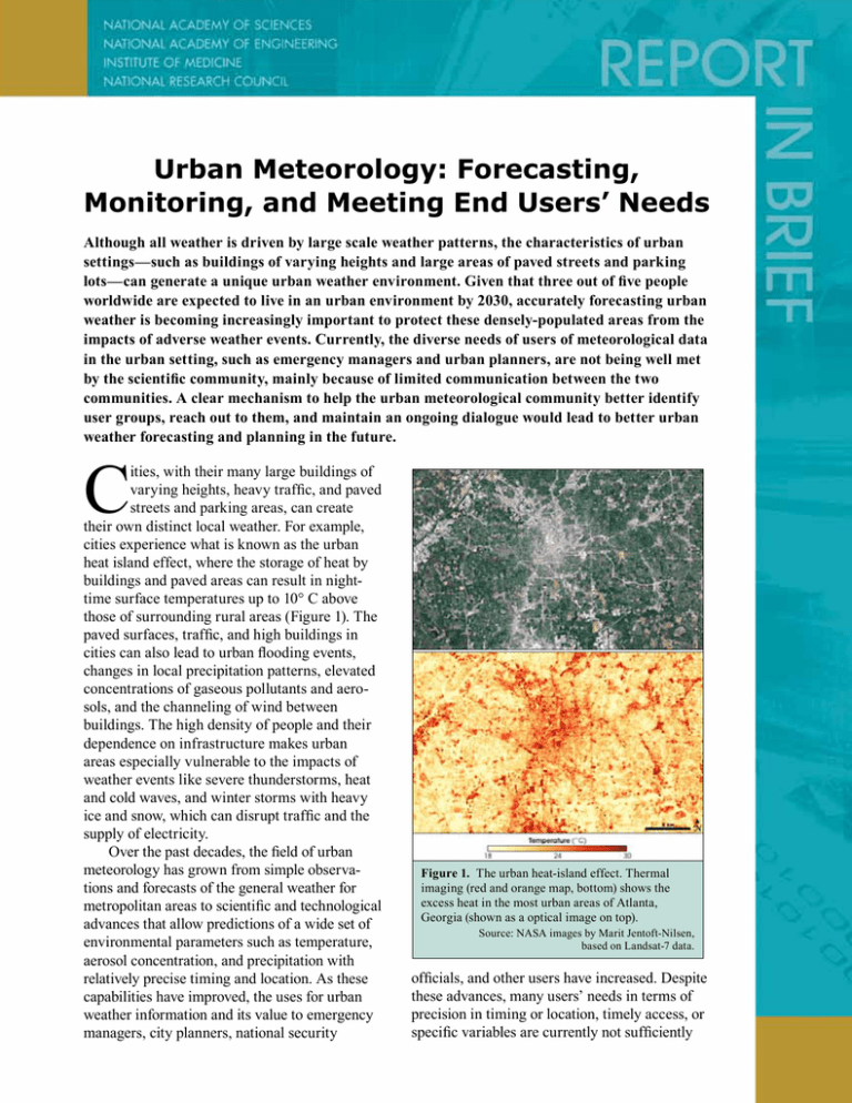
Urban Meteorology: Forecasting, Monitoring, and Meeting End Users’ Needs Although all weather is driven by large scale weather patterns, the characteristics of urban settings—such as buildings of varying heights and large areas of paved streets and parking lots—can generate a unique urban weather environment. Given that three out of five people worldwide are expected to live in an urban environment by 2030, accurately forecasting urban weather is becoming increasingly important to protect these densely-populated areas from the impacts of adverse weather events. Currently, the diverse needs of users of meteorological data in the urban setting, such as emergency managers and urban planners, are not being well met by the scientific community, mainly because of limited communication between the two communities. A clear mechanism to help the urban meteorological community better identify user groups, reach out to them, and maintain an ongoing dialogue would lead to better urban weather forecasting and planning in the future. C ities, with their many large buildings of varying heights, heavy traffic, and paved streets and parking areas, can create their own distinct local weather. For example, cities experience what is known as the urban heat island effect, where the storage of heat by buildings and paved areas can result in nighttime surface temperatures up to 10° C above those of surrounding rural areas (Figure 1). The paved surfaces, traffic, and high buildings in cities can also lead to urban flooding events, changes in local precipitation patterns, elevated concentrations of gaseous pollutants and aerosols, and the channeling of wind between buildings. The high density of people and their dependence on infrastructure makes urban areas especially vulnerable to the impacts of weather events like severe thunderstorms, heat and cold waves, and winter storms with heavy ice and snow, which can disrupt traffic and the supply of electricity. Over the past decades, the field of urban meteorology has grown from simple observations and forecasts of the general weather for metropolitan areas to scientific and technological advances that allow predictions of a wide set of environmental parameters such as temperature, aerosol concentration, and precipitation with relatively precise timing and location. As these capabilities have improved, the uses for urban weather information and its value to emergency managers, city planners, national security Figure 1. The urban heat-island effect. Thermal imaging (red and orange map, bottom) shows the excess heat in the most urban areas of Atlanta, Georgia (shown as a optical image on top). Source: NASA images by Marit Jentoft-Nilsen, based on Landsat-7 data. officials, and other users have increased. Despite these advances, many users’ needs in terms of precision in timing or location, timely access, or specific variables are currently not sufficiently being met. This National Research Council report assesses what is needed to better meet end user needs and describes current and emerging urban meteorological forecasting and monitoring capabilities. the high spatial variability, the unique physical charac­teristics of the urban environment, and the varied impacts of urban environments on meteorological processes. End User Needs Advances in Urban Observations The end users of urban meteorological data include power producers, municipal officials, insurance companies, and public health officials and cover a vast spectrum of job roles, goals, needs, experience, and understanding (Box 1). They need high quality information about different weather events in a wide variety of formats, and within time constraints set by their decision processes. Acknowledging and understanding these varied user needs is important for the urban meteorological community, which is sometimes unaware of the precise data and information needs of various user groups. If useful meteorological data are not provided, some groups of users might start generating their own data streams, not necessarily following best practices in data collection, analysis, or interpretation, which could lead to redundant or inconsistent information. Advances in Urban Meteorology Despite advances in the field of urban meteorology over the past few decades, weather observations and forecasting in cities remains complex because of Box 1. Who Uses Urban Meteorological Data? Urban meteorological data is used by a variety of agencies and companies. Often, however, the data available do not satisfy user needs in terms of precision of timing and location, timely access to data, or the exact variables they are interested in. Examples of users of urban meteorological data are: • Power producers, who use meteorological data on urban scales to estimate peak demands (e.g., due to heat or cold waves) and adjust energy production • Municipal officials, who use meteorological data for many purposes, among them to plan the capacity of combined storm and sewage systems, avoid the channeling of winds in new developments, to monitor urban air quality, and develop adaptation strategies through zoning changes • Insurance and reinsurance companies, who use the data to set their rates based on estimates of the probability of damages from extreme weather events like thunderstorms, tornados, hurricanes, and floods • Public health officials, who use the data for timely warnings and preparation for all kinds of extreme weather events, e.g., heat waves, storms, and air quality. Advancements related to aircraft and satellite remote sensing have been useful in assessing the extent and magnitude of the urban heat island, identifying urban rain- and snowfall anomalies, and determining air quality. Remote-sensing has also helped to properly characterize urban land cover and morphology, aerosols, and hydrometeorological parameters. Urban observational networks with multiple sensors per city have been deployed in several locations, improving urban weather forecasts. To further improve forecasts, a three-dimensional picture of the urban atmosphere is needed, which requires the integration of local measurements with remote-sensing data. Advances in Urban Modeling Using new techniques, some numerical weather prediction models now include explicit urban treatments. The methods used to “urbanize” weather models range from urban parameterizations in coarser resolution models to the actual simulation of the simplified urban environment in high-resolution models. Advances in atmospheric dispersion and urban air quality models provide better support for decision-makers, with several approaches available for neighborhood to street-scale dispersion modeling (Figure 2). These models are particularly useful to emergency managers, for example to provide fast and reliable predictions of the movement of plumes of toxic airborne contaminants in the event of an accidental or terrorist release. Hydrology models have also been improved for urban environments by adding the characteristics of urban surfaces such as roads and sidewalks that modify surface runoff and evaporation. Given that the majority of the U.S. population lives within coastal counties, predicting flooding due to coastal storm surges is increasingly important. Recent advances in storm surge models are beginning to address these needs by including population, land cover, elevation, meteorological, and oceanographic datasets in their simulations. Emerging Technologies Several emerging technologies in urban meteorological monitoring and forecasting have the potential to improve urban data products. An example is the use of nontraditional sensor networks, specifically • Figure 2. Simulation of a contaminant cloud in Chicago. Urban models like the FAST3DCT can simulate how a contaminant cloud moves within a city with street-level resolution. This image shows an overhead view of the contaminant concentrations over the Chicago River 468 seconds after its release. Source: Patnaik, G., J. P. Boris, F. F. Grinstein, and J. P. Iselin. 2005. “Large scale urban simulations with FCT.” Pp. 105-130 in Flux-Corrected Transport. D. Kuzmin, R. Löhner, and S. Turek, editors. Berlin: Springer Verlag, doi:10.1007/3-540-27206-2_4. measurements by mobile vehicles and the use of social networking technologies and text messages for the reporting of events or alerts. Emerging advances in modeling include the explicit use of land-use data in urban weather models and the application of probabilistic forecasting techniques to urban environments. Future Needs and Challenges To further advance the field of urban meteorology, there are short-term needs and longer-term challenges. Short-term needs can be addressed with relatively small investments while long-term challenges require larger investments. Short Term Needs 1. Maximum access to observational data in different categories from diverse sources Many end users would like observational data with more precision in timing and location. Although some of these data already exist, gaining access to them is often difficult. Data access can be maximized by: • securing access to existing data sets from previous urban campaigns, • assuring that long-term monitoring networks will serve needs of both the global and urban climate communities, and integrating data sets from various monitoring networks into central data archives that can be easily accessed by the broader science and end user communities. 2. Regularly updated metadata of the urban observations using standardized urban protocols Observational data have maximum value only if they are accompanied by comprehensive metadata —information about the data that helps facilitate its understanding and use. Without detailed metadata, observational data over varied urban areas can be easily misunderstood and misused. Given the quickly changing nature of urban areas, the site selection, quality assurance, and management of instruments and metadata are crucial. 3.Continued and expanded international urban model intercomparisons over urban areas To discover major model deficiencies model intercomparison projects are helpful – in these intercomparison projects several different models are run with the same or very similar setup to identify which techniques yield the best results and to identify model deficiencies in some or all models. Given that model intercomparisons can show how to improve urban models, continued and expanded international urban model intercomparisons for different urban types (e.g., coastal, mountainous, tropical, etc.) in developed and developing countries are needed. 4. Development and application of best practices to strengthen the dialog between meteorologists and end user communities Effective communication between urban meteorologists and end users is a challenge. To improve communications, it is important for meteorologists to better understand how individuals and organizations interpret forecast information and integrate it with other inputs, such as socioeconomic, political, and cultural factors, in decision-making processes. At the same time, it is just as important for end users to better understand how observational data and models generate forecasts and associated uncertainties. To change the current situation, best practices to strengthen the dialog between urban meteorologists and user communities should be developed. Challenges Beyond the short-term needs, some potentially valuable advances in urban meteorology and its usefulness to the user communities would require significant efforts and investments. The committee identified three overarching challenges that describe future needs in urban meteorology. 1. How can new capabilities for urban observations be developed and implemented, particularly using the network of personal digital assistants (PDAs—including smart phones), vehicles, and new technologies for measurements in the whole planetary boundary layer? The committee identified several approaches to meet continued needs for better meteorological observations in urban areas, particularly for threedimensional high-resolution data within the atmospheric/urban boundary layer. A promising approach to meet this challenge is the development of technologies that can integrate data from various sources, such as smart phones, vehicles, traditional stations, and remote-sensing data. 2. How can weather and climate models be urbanized and how can urban areas be included in the model prediction evaluation and validation metrics? Currently, many models do not include urban treatments or only include simplified representations. Further improvements in model physics and resolution will be needed to improve the representation of urban areas in weather and climate models. In addition, model evaluation and validation procedures based on high-resolution urban data need to be developed to advance model skills. 3. How will the capability for integrated urban meteorology-decision support systems be developed? A combination of complementary approaches, with the integration of skills from the user and the meteorology communities, may help develop support for urban meteorological decision makers. The possible approaches include the development of joint urban meteorological decision support exercises, the joint training of graduate students to address the interdisciplinary knowledge gaps, and the attendance of joint conferences and workshops. Read or purchase this report and locate information on related reports at http://dels.nas.edu/basc Committee on Urban Meteorology: Scoping the Problem, Defining the Needs: John T. Snow (Co-chair), University of Oklahoma, Norman; Xubin Zeng (Co-Chair), University of Arizona, Tucson; Petra Klein, University of Oklahoma, Norman; Stefanie Ebelt Sarnat, Emory University, Atlanta, Georgia; J. Marshall Shepherd, University of Georgia, Athens; Ellis M. Stanley, Dewberry, Los Angeles; Katie Thomas (Associate Program Officer), Elizabeth Finkelman (Senior Program Assistant), National Research Council The National Academies appointed the above committee of experts to address the specific task requested by the National Aeronautics and Space Administration, National Oceanic and Atmospheric Administration, and National Science Foundation. The members volunteered their time for this activity; their report is peerreviewed and the final product signed off by both the committee members and the National Academies. This report brief was prepared by the National Research Council based on the committee’s report. For more information, contact the Board on Atmospheric Sciences and Climate at (202) 334-3512 or visit http://dels.nas.edu/ basc. Copies of Urban Meteorology: Forecasting, Monitoring, and Meeting End Users’ Needs are available from the National Academies Press, 500 Fifth Street, NW, Washington, D.C. 20001; (800) 624-6242; www.nap.edu. Permission granted to reproduce this brief in its entirety with no additions or alterations. Permission for images/figures must be obtained from their original source. © 2012 The National Academy of Sciences
