Document 11943931
advertisement
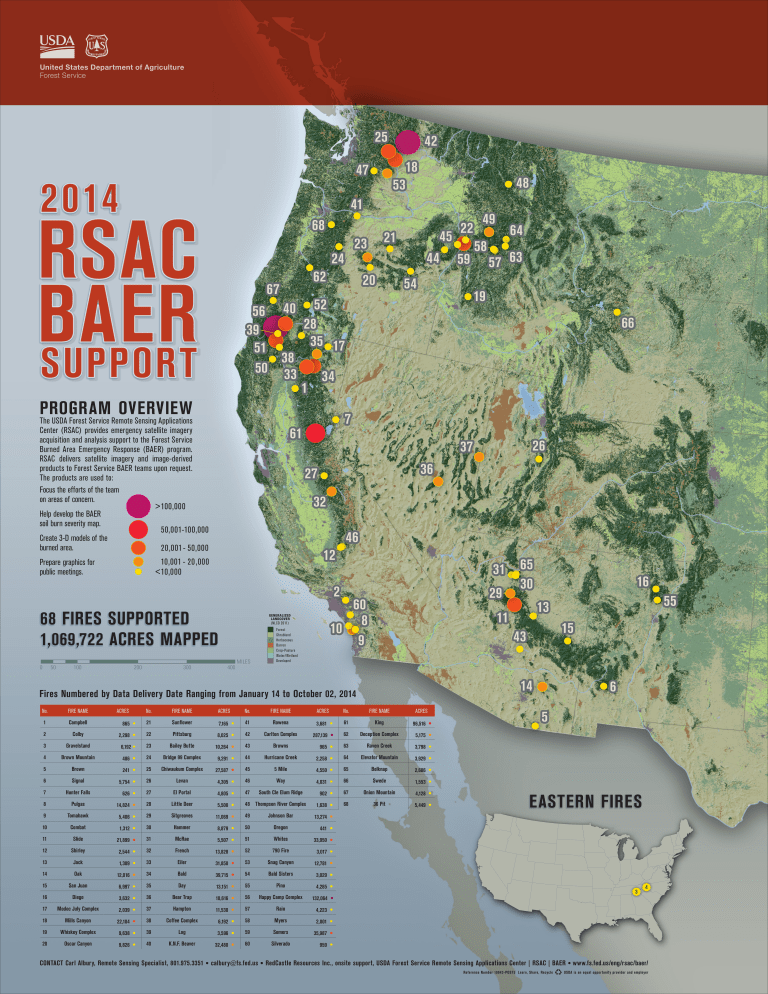
United States Department of Agriculture Forest Service 25 18 47 2014 48 53 41 RSAC BAER SUPPORT 68 62 67 45 21 23 24 44 20 The USDA Forest Service Remote Sensing Applications Center (RSAC) provides emergency satellite imagery acquisition and analysis support to the Forest Service Burned Area Emergency Response (BAER) program. RSAC delivers satellite imagery and image-derived products to Forest Service BAER teams upon request. The products are used to: Focus the efforts of the team on areas of concern. > 100,000 Help develop the BAER soil burn severity map. 50,001-100,000 Create 3-D models of the burned area. 20,001 - 50,000 300 19 32 46 12 65 31 30 29 60 8 10 9 GENERALIZED LANDCOVER (NLCD 2011) 400 No. FIRE NAME ACRES No. FIRE NAME ACRES 1 Campbell Sunflower 7,165 2 Colby 22 Pittsburg 8,025 3 Gravelstand 23 Bailey Butte 10,264 4 Brown Mountain 24 Bridge 99 Complex 9,291 5 Brown 25 Chiwaukum Complex 27,587 6 Signal 26 Levan 4,305 7 Hunter Falls 27 El Portal 4,805 8 Pulgas 28 Little Deer 5,500 9 Tomahawk 29 Sitgreaves 11,069 10 Combat 30 Hammer 8,879 11 Slide 31 McRae 5,507 12 Shirley 32 French 13,828 13 Jack 33 Eiler 31,850 14 Oak 34 Bald 39,715 15 San Juan 35 Day 13,151 16 Diego 36 Bear Trap 10,616 17 Modoc July Complex 37 Hampton 11,530 18 Mills Canyon 38 Coffee Complex 6,192 19 Whiskey Complex 39 Log 3,596 20 Oscar Canyon • 2,298 • 6,192 • 486 • 241 • 5,754 • 626 • 14,824 • 5,406 • 1,312 • 21,899 • 2,544 • 1,309 • 12,016 • 6,997 • 3,632 • 2,039 • 22,104 • 9,638 • 9,826 • 21 40 K.N.F. Beaver 32,480 CONTACT Carl Albury, Remote Sensing Specialist, 801.975.3351 26 36 MILES Forest Shrubland Herbaceous Barren Crop-Pasture Water/Wetland Developed 11 • • • • • • • • • • • • • • • • • • • • FIRE NAME ACRES No. FIRE NAME 41 Rowena King 96,516 42 Carlton Complex 62 Deception Complex 5,175 43 Browns 63 Raven Creek 3,798 44 Hurricane Creek 64 Elevator Mountain 3,929 45 5 Mile 65 Belknap 2,686 46 Way 66 Swede 1,553 47 South Cle Elum Ridge • 287,139 • 965 • 2,258 • 4,550 • 4,031 • 902 • 1,638 • 13,274 • 441 • 33,950 • 3,017 • 12,781 • 3,029 • 4,285 • 132,064 • 4,223 • 2,001 • 35,987 • 959 • 61 67 Onion Mountain 4,128 68 36 Pit 5,449 48 Thompson River Complex 49 Johnson Bar 50 Oregon 51 Whites 52 790 Fire 53 Snag Canyon 54 Bald Sisters 55 Pino 56 Happy Camp Complex 57 Rain 58 Myers 59 Somers 60 Silverado ACRES • • • • • • • • 55 13 15 14 No. 3,681 16 43 Fires Numbered by Data Delivery Date Ranging from January 14 to October 02, 2014 865 63 57 66 27 1,069,722 ACRES MAPPED 200 58 64 37 10,001 - 20 ,000 < 10,000 100 49 7 61 1:12,000,000 68 FIRES SUPPORTED 50 59 54 2 0 22 52 56 40 28 39 35 17 51 38 50 33 34 1 PROGRAM OVERVIEW Prepare graphics for public meetings. 42 6 5 EASTERN FIRES 3 4 • calbury@fs.fed.us • RedCastle Resources Inc., onsite support, USDA Forest Service Remote Sensing Applications Center | RSAC | BAER • www.fs.fed.us/eng/rsac/baer/ Reference Number 10043-POST5 Learn, Share, Recycle USDA is an equal opportunity provider and employer
