DEVELOPMENT OF AN ADVANCED UNCERTAINTY MEASURE FOR CLASSIFIED REMOTELY SENSED SCENES
advertisement

DEVELOPMENT OF AN ADVANCED UNCERTAINTY MEASURE
FOR CLASSIFIED REMOTELY SENSED SCENES
J. Schiewe, C. Kinkeldey
HafenCity University Hamburg, Lab for Geoinformatics and Geovisualization (g²lab)
Hebebrandstr. 1, 22297 Hamburg, Germany
{jochen.schiewe, christoph.kinkeldey}@hcu-hamburg.de
KEY WORDS: classification, uncertainty, quality assessment, fuzzy borders, transition zones
ABSTRACT:
Classified remotely sensed data serves as the basis for various types of city models. Since the requirements concerning the
correctness of these models are rapidly growing, the demands for a significant assurance of their quality increase as well. Standard
methods for the a posteriori evaluation of classified data have successfully been applied but they do not fully meet the
requirements resulting from recent developments, primarily the higher geometric and thematic accuracies of modern sensor
systems. One consequence is that the uncertainties inherent in all kinds of data cannot be ignored anymore – not even those in the
so-called ground truth data which is used as reference in the quality assessment process. Hence, we propose an integrated
approach that considers uncertainties in both the classification and the reference data. The phenomenon of indeterminate
boundaries – another effect of more accurate remote sensing data – is treated using a border model based on fuzzy logic.
This paper describes the overall concept (section 1) as well as its key steps, the generation of transition zones including the
fuzzification process (section 2) and the derivation of the advanced uncertainty measure (section 3). In section 4 we present an
example application of the concept dealing with the evaluation of a classified orthophoto scene.
1. CONCEPTUAL OVERVIEW
Basically, the conventional evaluation procedures for classified
remote sensing data (especially in connection with a
comparison between classification result and reference) take
the reference data to be error-free (ground truth). This
assumption is certainly acceptable for lower resolution remote
sensing data due to a larger probability of the existence of
reference data of higher order. But for high resolution data
uncertainties in the reference data should not be neglected
because of the worse ‘relative resolution’ between reference
and sensor data. Consequently, we propose an integrated
evaluation method which considers uncertainties in the
reference data as well.
Due to the higher spatial resolution the effect of indeterminate
boundaries between certain object classes is increased in terms
of the absolute number of pixels of the respective transition
zones. Although adapted methods (like fuzzy logic approaches)
have been developed for the actual thematic classification,
analogous fuzzy logic methods for evaluation purposes are
hardly applied.
We propose an integrated fuzzy approach which deals with the
issue of indeterminate boundaries by the definition of buffer
zones around the object boundaries. This allows for the
computation of the class-specific fuzzy certainty measure
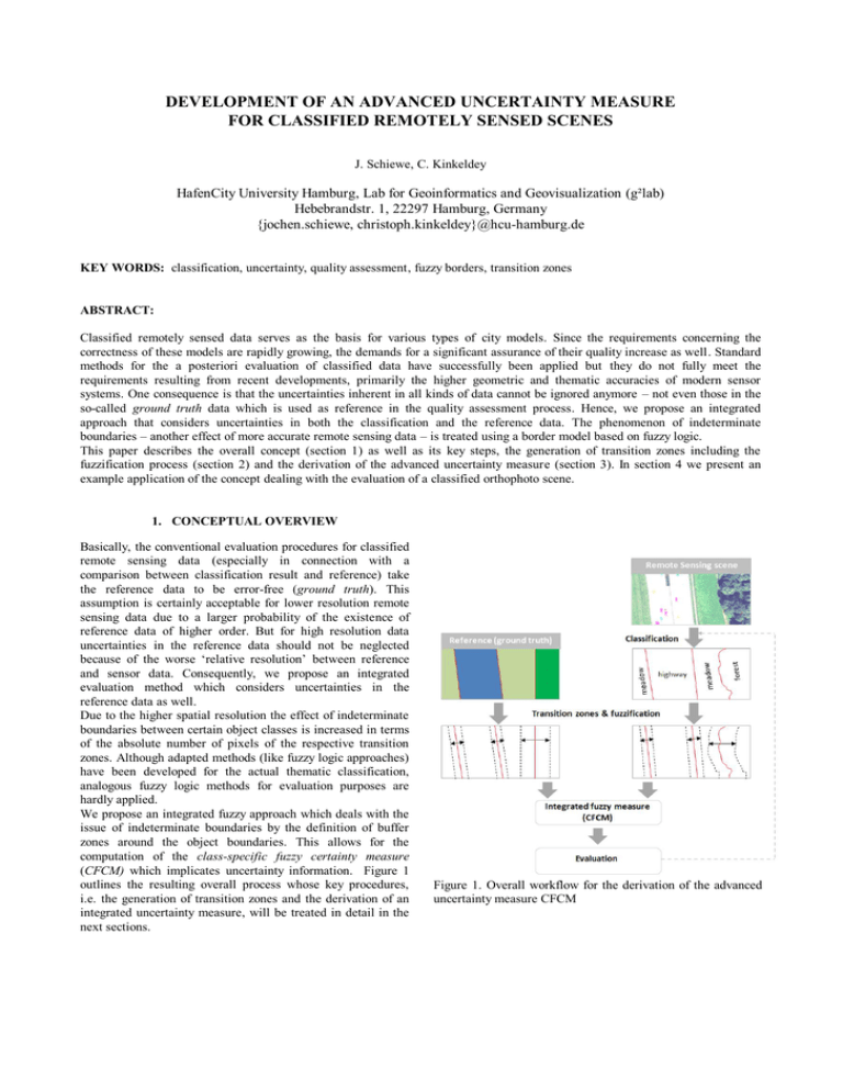
(CFCM) which implicates uncertainty information. Figure 1
outlines the resulting overall process whose key procedures,
i.e. the generation of transition zones and the derivation of an
integrated uncertainty measure, will be treated in detail in the
next sections.
Figure 1. Overall workflow for the derivation of the advanced
uncertainty measure CFCM
2. GENERATION OF TRANSITION ZONES
2.1 Idea and previous work
During an interpretation process rules for the allocation of an
image object to a given (topographic) class normally assume
determinate, discrete boundaries between these objects.
However, in high resolution remotely sensed data larger
regions (i.e. a larger number of pixels) evolve between classes
(e.g. along the boundary of a forest) which make a unique
allocation impossible or at least very subjective. Such
indeterminate transition zones originate from limited positional
accuracies or insufficient semantic definition of objects and
their boundaries. Using modern sensors this fuzziness effect is
even more severe due to the smaller ground pixel sizes. The
spectral variance within regions representing a single
topographical object increases and this leads to a larger
number of mixed elements (e.g. forest consists of trees, bare
ground, etc.).
For modeling indeterminate regions within a classification
process the application of (ε-) bands (refer to Chrisman, 1992)
and the fuzzy logic theory have been proposed. With respect to
the latter the concept of varying memberships to a class (from
‘no membership at all’ to ‘perfect membership’) along with its
application for classification tasks, have been demonstrated by
Fisher (2000). Also Wang (1990) warrants the application and
proposes the derivation of a fuzzy partition matrix which
summarizes the membership values of a feature to every
possible class as defined in the object catalogue. Edwards &
Lowell (1996) define a membership function for the
description of spatial uncertainties. Here for all pairs of objects
classes (so-called twains) fuzzy widths are introduced based on
the mean deviations derived from repeatedly digitizing
boundaries from aerial photos.
2.2 Geometric aspects
The transition zones serve as a model of the boundary area
between two classified geographical objects. Their geometry is
constructed depending on the kind of object pair. Basically it is
assumed that the transition areas are symmetric, i.e. two
adjacent objects share the same transition zone geometry.
In order to create the geometries for these zones the boundaries
are buffered on both sides (figure 2). The boundary width
depends on the classes of the respective objects and is
determined in advance on the basis of semantic aspects for
each occurring pair of object classes (see section 2.3). Inside of
the transition zone a fuzzy membership function is defined
perpendicular to the object's boundary. The result is a function
that provides a value of 1.0 (full membership to an object
class) on the inner boundary of the transition zone and a value
of 0.0 (no membership) on the outer boundary.
Currently, the concept is limited to linear fuzzy functions but
future research will consider non-linear membership functions
as well. It appears reasonable to apply different kinds of fuzzy
functions in order to consider the shape of different transitions
between certain objects.
In the case of an object with multiple neighbouring objects, its
boundary is being split up and the partial boundaries are
buffered separately. After this, all single zones along each
boundary are aggregated to an overall zone using a standard
union operation (see the example application in chapter 4).
Figure 2. Generation of transition zones and fuzzification per
class
2.3 Semantic aspects
As already pointed out, the thematic membership of the
neighbouring objects have a significant influence on the
fuzziness of the boundary and the width of the transition zone
(Edwards & Lowell, 1996). A generally accepted specification
for the width of border regions in terms of absolute numbers is
virtually not possible due to a couple of factors like different
ground sampling distances, seasonal influences or up-todateness. Alternatively, a qualitative approach for the
definition of the width of boundary regions can be transferred
from ecology. Jalas (1955) and Sukopp (1972) developed a
system that describes the intensity of human influences,
distinguishing between ‘natural habitats’ and ‘artificial
habitats’. Based on that, regions under consideration are
classified on a scale from ahemerob (natural) to polyhemerob
(artificial) – which is a measure for the influence of mankind
on landscape. First approaches for the combination of the
degree of naturalness with remote sensing data have been
developed in the Austrian SINUS-project (refer to Wrbka et al.
2003). In this project a statistical correlation has been
determined between landscape metrices calculated from remote
sensing data and the degree of naturalness.
Based on these results and our own test series we have started
with a qualitative definition of boundary region widths. The
result is a ranking that includes typical object class pairs and
their boundary width in relation to each other (on a scale from
‘0’ to ‘+++++’).
This guideline helps us to assign absolute, quantitative zone
widths to the object classes of a specific classification dataset.
This must be done with respect to the characteristics of the
classification data and the used object class catalogue
(minimum mapping unit, quality of data sources etc.).
Obviously, expert knowledge is needed for this initial step of
the process so our aim is to build up a collection of parameters
for common landcover / landuse catalogues (e.g. CORINE
Landcover) being transferable to different datasets of the same
classification product.
3. DERIVATION OF THE CHARACTERISTIC VALUE
3.1 Definition
The class memberships of a pixel or a region within the
reference (μREF) and in the classification result (μCLASS) as
described in the previous section form the basis for the
derivation of the class-specific fuzzy certainty measure
(CFCM). Outside of the transition zones the class memberships
can either be 1.0 (if the point lies within an object of the class)
or 0.0 (if it does not). Inside of the transition zones the class
memberships are determined by the fuzzy function leading to a
value within the interval [0.0, 1.0].
Computing the difference between the class memberships μREF
and μCLASS yields the overall certainty measure for each class
as follows:
Figure 3a. Comparison of ground truth and classification.
Without fuzzy borders the coincidence at the marked position
is characterized as ‘false’.
1 n
| µi, REF (c) µi,CLASS (c) |
n i 1
0 µi ,CLASS 0
CFCM (c) 1
i | µi , REF
μREF(c): class membership value of a pixel / area for class c in
reference data
μCLASS(c): class membership value of a pixel / area for class c
in classification data
n: number of pixels / areas under examination
A high resulting CFCM value for a certain class expresses a
high accordance between the objects of the class in the
reference dataset and the classification. The CFCM can be
computed for specific topographical classes either in an entire
scene or in arbitrary areas such as single objects.
Figures 3a and 3b demonstrate the effect of the advanced
uncertainty measure CFCM (in a qualitative manner) in
comparison to a conventional approach. Concerning the latter
the evaluation results in a binary decision (in the presented
case a classification as ‘false’). In contrast to this, the
transition zone definition (figure 3b) considers the effect of
indeterminate boundaries – the degree of coincidence is
expressed by a CFCM value being larger than 0 (but still
clearly below 1.0).
The benefit from the advanced method is that the statement
about the (un-)certainty of the classification allows for a much
more differentiated conclusion about the quality of the dataset.
One intended effect is that geometric differences in the object
boundaries resulting from class definition characteristics and
interpretation tolerance are weighted less compared to ‘real’
differences (e.g. divergent allocation of an object to a class).
Figure 3b. The advanced uncertainty measure CFCM uses
fuzzy borders. The coincidence at the marked position is
characterized as ‘neither completely false nor true’ – a value
between 0 and 1.
4. EXAMPLE OF USE
Apart from a range of synthetic test scenarios we apply our
concept on first datasets based on real high resolution remote
sensing scenes. The most important aim is to gather experience
with the transition zone model, especially regarding the
definition of the fuzzy border geometry (zone widths) on the
basis of the existing semantic information. One of the
examples is presented in this chapter.
We consider two classification datasets of a research area in
the region around Hamburg, Germany – a residential area next
to a forest and an agricultural area. From a student project we
have obtained multiple manual classifications of this area on
the basis of orthophoto material (pixel-resolution of 10 cm).
We have selected two of them in order to demonstrate the
process by means of the forest object contained in this dataset
(see figure 5).
residential
area
residential
area
road
agriculture
forest
road
agriculture
forest
1m
4m
10 m
-
5m
Table 1. Object classes and pairwise zone widths.
road
residential area
Figure 6. Definition of the transition zones for the forest object
with different zone widths for agriculture (2x5 m) and
residential area (2x10 m).
agriculture
forest
Figure 5. Two different manual classifications based on an
orthophoto scene.
(c) Freie und Hansestadt Hamburg, Landesbetrieb Geoinformation und Vermessung
The first step is to compile the existing landcover classes and
define the degree of uncertainty for the occurring object class
pairs. Table 1 shows the assignment of fuzzy zone widths to
the object classes whereas a value of 1 m results in a
symmetric buffer zone with 2x1 m (1 m to both sides of the
border). The choice of the values has been done according to
their degree of naturalness (see 2.3) and our experience from
multiple classifications. The largest zone width is assigned to
the boundary between ‘forest’ and ‘residential area’ in contrast
to the ‘road’ class which separates from ‘residential area’ quite
clearly. Figure 6 shows the transition zone of the forest object
completed by a detail view of the buffer between ‘forest’ and
‘residential area’ in figure 7.
Figure 7. Detail view of transition zones in the boundary area
between ‘forest’ and ‘residential area’.
According to our concept the following steps have been
performed:
1. Splitting up the boundaries according to adjacency
→ partial boundaries
2. Buffering of each partial boundary with the
respective width according to its object pair
3. Merging the partial buffers of each object to one ring
buffer → transition zone
4. Application of (here: linear) fuzzy function → fuzzy
memberships
After defining the transition zones we are able to determine the
membership to a class for each point in the dataset. Figure 8
presents the membership values for class ‘forest’ ranging from
1.0 (inside the object) to 0.0 (outside) including values in
between within the transition zones.
Figure 9. CFCM distribution for class ‘forest’.
Apart from this distribution data that can be used for an
uncertainty examination we compute the mean value of all
CFCM values for each class which yields in one single value.
The outcome for this example is compiled in table 2. The
CFCM figures express the agreement between the two
classified datasets considering the fuzziness of the contained
objects. One can see that the values are close to 100% aside
from the road object which shows an accordance below 80%
which is due to the different interpretation of the two editors in
respect to a dead-end street (see figure 5).
This example points out how the CLAIM concept supports the
assessment of classification quality with the help of an
uncertainty model. A number of applications will follow in the
near future to support the further development of the concept.
Figure 8. Membership values for ‘forest’ (Classification A).
From the membership values, the quality measure can be
obtained:
1. Computation of CFCM measure for each object class
(for the whole area)
2. Computation of mean CFCM value for each class
The software implementation performs the whole process
automatically so that the manual effort for the computation is
limited to the provision of the parameters. The following
outputs are created by the software:
The buffer zones
The membership values
The CFCM distribution for each class
One overall CFCM value for each class
Figure 9 exemplarily shows the distribution of the CFCM
values for class ‘forest’. It depicts the certainty of the forest
object which turns out to be relatively low at the northern
boundary adjacent to the residential area whereas the border
area between the forest and the agriculture object is evaluated
as more certain.
residential
area
road
agriculture
96,09%
78,37%
98,45%
CFCM
Table 2. Mean CFCM value for object classes
forest
96,77%
5. STATUS AND OUTLOOK
7. REFERENCES
The presented concept of modeling indeterminate transition
zones in both the reference and the classified data allows for a
well founded description of uncertainty in classified remotely
sensed data. With that the derivation of fuzzy logic
membership values becomes possible which leads to an
advanced certainty measure named class-specific fuzzy
certainty measure CFCM, giving the desired quantitative,
integrated evaluation of the classification accuracy.
The discussed model has already been implemented as Java
software that allows for automated test series based on
synthetic and real data. This and the integration of additional
expert knowledge will help to further develop and quantify the
needed control parameters (e.g. for determining the width and
the symmetry properties of transition zones). The choice of
zone widths plays an important role; that is why the definition
of parameters sets for standard landcover / landuse catalogues
is intended.
The assignment of the zone widths is currently done under
consideration of class-specific attributes. The extension of this
concept by the provision for object-specific criteria (size, shape
etc.) seems promising and will be one of our next steps of
further development leading to an object-specific certainty
measure.
Connected to this we will continue with the successive
expansion of our CLAIM software library that will be available
under open source license in order to gain as much user
feedback as possible.
Chrisman, N.R., 1982. A Theory of Cartographic Error and Its
Measurement in Digital Databases. AUTOCARTO, (5), pp.
159-168.
Edwards, G. & Lowell, K.E., 1996. Modeling Uncertainty in
Photointerpreted Boundaries. Photogrammetric Engineering &
Remote Sensing. 62(4), pp. 337-391.
Fisher, P., 2000. Sorites paradox and vague geographies. Fuzzy
Sets and Systems, (113), pp. 7-18.
Jalas, J., 1955. Hemerobe und hemerochore Pflanzenarten. Ein
terminologischer Reformversuch. Acta Soc. Flora Fauna
Fennicia, (72), pp. 1-15.
Schiewe, J., Ehlers, M., Kinkeldey, C. & Tomowski, D., 2009.
Modellierung von Unsicherheiten in klassifizierten, räumlich
hoch aufgelösten Fernerkundungsszenen. Tagungsband der
Jahrestagung
der
Deutschen
Gesellschaft
für
Photogrammetrie, Fernerkundung und Geoinformation
(DGPF), Jena.
Sukopp, H., 1972. Wandel von Flora und Vegetation in
Mitteleuropa unter dem Einfluß des Menschen. Berichte über
Landwirtschaft, 50, pp. 112-139.
Wang, F., 1990. Improving Remote Sensing Image Analysis
through Fuzzy Information Representation. Photogrammetric
Engineering & Remote Sensing. 56(8), pp. 1163-1169.
Wrbka,
T.
et
al.,
2003.
Landschaftsökologische
Strukturmerkmale als Indikatoren der Nachhaltigkeit, final
report of "SINUS" research project, Federal Ministry of
Education and Research, Vienna, Austria (CDROM).
6. ACKNOWLEDGEMENTS
The presented work is part of the project CLassification
Assessment using an Integrated Method (CLAIM) which is
currently funded by the German Research Foundation (DFG).
Many thanks to Anne Lübcke for the illustrations in chapter 4.


