5 International Conference on 3D Geoinformation The 5
advertisement
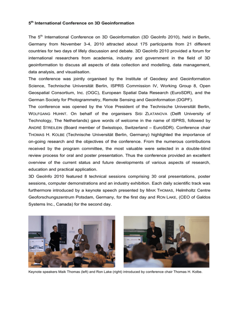
5th International Conference on 3D Geoinformation The 5th International Conference on 3D Geoinformation (3D GeoInfo 2010), held in Berlin, Germany from November 3-4, 2010 attracted about 175 participants from 21 different countries for two days of lifely discussion and debate. 3D GeoInfo 2010 provided a forum for international researchers from academia, industry and government in the field of 3D geoinformation to discuss all aspects of data collection and modelling, data management, data analysis, and visualisation. The conference was jointly organised by the Institute of Geodesy and Geoinformation Science, Technische Universität Berlin, ISPRS Commission IV, Working Group 8, Open Geospatial Consortium, Inc. (OGC), European Spatial Data Research (EuroSDR), and the German Society for Photogrammetry, Remote Sensing and Geoinformation (DGPF). The conference was opened by the Vice President of the Technische Universität Berlin, WOLFGANG HUHNT. On behalf of the organisers SISI ZLATANOVA (Delft University of Technology, The Netherlands) gave words of welcome in the name of ISPRS, followed by ANDRÉ STREILEIN (Board member of Swisstopo, Switzerland – EuroSDR). Conference chair THOMAS H. KOLBE (Technische Universität Berlin, Germany) highlighted the importance of on-going research and the objectives of the conference. From the numerous contributions received by the program committee, the most valuable were selected in a double-blind review process for oral and poster presentation. Thus the conference provided an excellent overview of the current status and future developments of various aspects of research, education and practical application. 3D GeoInfo 2010 featured 8 technical sessions comprising 30 oral presentations, poster sessions, computer demonstrations and an industry exhibition. Each daily scientific track was furthermore introduced by a keynote speech presented by MAIK THOMAS, Helmholtz Centre Geoforschungszentrum Potsdam, Germany, for the first day and RON LAKE, (CEO of Galdos Systems Inc., Canada) for the second day. Keynote speakers Maik Thomas (left) and Ron Lake (right) introduced by conference chair Thomas H. Kolbe. During his introductory keynote presentation MAIK THOMAS pointed out, that 3D Geoinformation will play an important role for Earth system modelling in the future. On one hand the complex relationship between numerous monitored Earth system data of different kinds and the biological, ecological and climatic models has to be described. On the other hand the need for an exact determination of the relevant model parameters requires techniques which are especially provided by Geoinformation Sciences, and their techniques for the interpretation of spatially distributed 3D data. Among others, future challenges are to develop generic data formats, concepts for efficient processing chains and interoperable software architectures to answer the question "How can we change the vast amount of data to information?" RON LAKE stressed that information sharing in use and creation of city models is a main prerequisite for success and sustainability. Since cities are complex and dynamic, city models must meet the challenge of responding to this dynamic nature. There is a need for an event driven sharing infrastructure. Tools for automated aggregation, integration, distribution and sharing of data are necessary. Not only planners and architects have to be involved in the design and evolution, but also engineers and the general public. In any case city models should provide rich semantics and can best be exploited through the use of collaboration and sharing over the Web. Session 1: Energy Assessment with 3D City Models LARS BODUM (Aalborg University, Denmark) reported on the project „EnergyCity‟. The 3D city model of Frederikshavn in the north part of Denmark was enhanced into an energy system. Offering a graphical user interface for adjusting energy parameter, users can immediately realize how the change of energy consumptions matters, which may help to convey decisions by energy planning experts and politicians and to realize a more sustainable while feasible energy scenario. DANIEL CARRION (Technische Universität Berlin, Germany) proposed a method for the estimation of the energetic rehabilitation state of buildings. Combining data from the 3D City model of Berlin with real measured heating energy data, energy relevant building characteristics can be determined. Using these results, estimations of the energetic rehabilitation state are derived. Session 2: 3D Spatial and Semantic Building Modelling Modelling of building interiors was in the focus of the report of PAWEL BOGUSLAWSKI (University of Glamorgan, Wales, UK). The feasibility of an appropriate data structure that had been developed during the last years was ascertained by two complex, linked university building models. LÉON VAN BERLO (TNO, The Netherlands) described the development of a CityGML extension called GeoBIM to get semantic IFC data into a GIS context. The conversion of IFC to CityGML (including the GeoBIM extension) is implemented in the open source Building Information Modelserver. A related topic „Towards Interoperating CityGML and IFC Building Models: A Unified Model Based Approach‟ was covered by MOHAMED EL-MEKAWY (Future Position X, Sweden). He presented the development of a unified building model used as intermediate model for the two-step conversion from IFC to CityGML and vice versa. This approach was demonstrated successfully on a real hospital building in Sweden. The last speaker in session 2, ANDRÉ BORRMAN (Technische Universität München, Germany), introduced a spatial query language for 3D building and 3D city models that provides metric (closerThan, fartherThan, etc.), directional (above, below, northOf, etc.) and topological operators (touch, within, contain, etc.) for use in SQL statements. Moreover he presented the algorithms developed for implementation of these spatial operators. Session 3: 3D Data Acquisition, Management and Processing The contribution of LANGYUE WANG (York University, Canada) covered an integrated framework for the reconstruction of full 3D building models, in which both 3D indoor and outdoor model are constructed in a collaborative manner by fusing airborne laser scanning (ALS) data, terrestrial laser scanning (TLS) data, and architectural plans. A preliminary test proved the feasibility of his concept. MARTIN CHRISTEN (University of Applied Sciences Northwestern Switzerland) presented a technique to create a Delaunay triangulation for terrain visualisation on a virtual globe. This method can be used to process large-scale elevation datasets with billions of points even on computer with little RAM. All data is being transformed to a global spatial reference system. If grid based elevation data is used as input, a reduced TIN is calculated. Furthermore, a level of detail approach for large-scale out-of-core spherical terrain rendering for virtual globes was presented. MARTIN HOPPEN (RWTH Aachen University, Germany) introduced a new method for combining 3D simulation systems with object-oriented geo data sources. Synchronising on schema and on object level in both worlds grant high flexibility and avoid unnecessary offline data conversion. The speaker emphasised the huge potential of this approach for single- as well as for multi-client applications and presented the adaptability to different fields of applications. Session 4: 3D Geo-Visualisation Session 4 started with an excursus in the field of perception psychology that was given by ANJA MATATKO (University of Trier, Germany). She reported on an empirical study to find out which factors of depth perception must be applied to improve cognition of spatial environments. Recommendations to map makers, allowing enhanced interpretation of thematic 3D cityscapes were given. XIAO XIE (Wuhan University, P.R. China) proposed an extended semantic model based on CityGML that supports a geology class in the thematic model and adjusts the building model introducing new classes suitable for indoor navigation. Moreover, she reported on the development of a semi-automatic data integration tool. Two exploration cases demonstrated the utilisability of the approach. Interactive rendering techniques for highlighting in 3D geovirtual environments were the topic of MATTHIAS TRAPP (Hasso-Plattner-Institute, University of Potsdam, Germany). Highlighting is an important component within a visualization framework and enables the user to easily perceive active or selected objects in the context of the current interaction task. Various highlighting techniques were introduced; its suitability for interactive rendering with high geometrical complexity was identified. Session 5: Enriching 3D City Models Automatic texture mapping is an important task in enrichment of the common 3D city models. DOROTA IWASZCZUK (Technische Universität München, Germany) introduced a concept for assignment of textures to partially occluded faces of 3D city models stored in CityGML. She emphasised that topological information between buildings as priori information of invisible faces should be used to improve the efficiency of the automatic texturing process. In order to support risk analysis and planning of emergency response actions, caused by cascading effects of different utility networks, modelling these infrastructures in 3D space is required, considering mutual dependencies. THOMAS BECKER (Technische Universität Berlin, Germany) explained requirements and introduced a novel framework for an integrated 3D modelling. Utility network components are modelled according to their 3D topography and by a complementary graph structure embedded into 3D space. IHAB HIJAZI (Universität Osnabrück, Germany) reported on the joint activities of the university Osnabrück, TU Delft, TU Berlin, and TNO for modelling utilities. Since interior utility is modelled using BIM and exterior using GIS, BIM/GIS integration is essential. Preliminary ideas and directions for how to acquire information from BIM/Industry Foundation Class (IFC) and map it to CityGML utility network Application Domain Extension (ADE) were given and illustrated by several examples. Session 6: 3D / 4D Spatial Modelling Concepts During the process of modelling the real world by creating a mathematical model the Euclidian geometry of space has to be mapped to the computational model with its finite precision. This can lead frequently to errors or unexpected results. In order to provide a rigorous logic in 2D or 3D within the computational arithmetic, PETER VAN OOSTEROM (University of Technology, OTB, The Netherlands) presented the concept of a regular polytope. This logic allows the derivation of a rich set of computable predicates and spatial functions. The applicability of this approach was proven on Cadastral data. W.L. (PIM) BIL (Gemeente Amstelveen, The Netherlands) proposed to model space on the 4D unit sphere, which means that space is considered to be the stereographic projection of the 4D unit sphere. The advantages of this approach were demonstrated by an example in two dimensions: Rejecting a 2D Voronoi diagram on the 3D unit sphere causes that Delaunay triangulation in the plane corresponds to the convex hull on the 3D unit sphere. As a straightforward example, Voronoi cells around given points in space are determined from the convex hull in the model. As a proof of principle the theory has been implemented in software. For modelling continuous phenomena raster structures or - to overcome the shortcomings of raster - Voronoi diagrams are used in most cases. Since construction and manipulation is complex and requires specialised tools for spatial applications, HUGO LEDOUX (Delft University of Technology, The Netherlands) proposed the use of the 3D discrete Voronoi diagram (DVD). In his talk he explained intuitively the algorithms to construct and manipulate the discrete 2D and 3D DVD, and demonstrate its use in practice with an own built prototype. EDWARD VERBREE (Delft University of Technology, the Netherlands) focused on Delaunay tetrahedralization and discussed how to handle degenerated cases. He introduced as „glue‟ between two degenerated neighbour tetrahedral an extra type of „non-geometrical‟, flat, zerovolume tetrahedra. The four vertices of these flat tetrahedra lie on the same circumsphere as the vertices of their neighboring tetrahedra. This makes it possible to perform a tetrahedralization without exact arithmetic, and without geometrical or symbolic perturbations. Session 7: Analysis of 3D Geospatial Informantion VINCENT THOMAS (Université Laval, Quebec City, Canada) reported on a citizen-based 3D modelling solution to enable mobile augmented reality applications on a smartphone. Data acquisition is achieved in a three tear approach: retrieval of 2D coordinates of a building of interest, computation of the altitude at its top corners, and finally the 3D modelling process and the augmentation of the reality. The proposed solution has been designed for the specific context in unprepared environment and was tested on an iPhone. Simplifying navigation in a 3D world is the concern of MICKAËL BRASEBIN (Institut Géographique National, France). In his presentation he proposes adding a visual clue – a disc – as overlay to maps. This disc is composed in different sectors, giving the user information on points of interest (POI) such as sights, restaurants, etc., but also can represent injured people, vulnerable buildings etc. in crisis scenarios. The information is controlled by three sector parameters: colour - representing the density of POI, angle – indicating the direction of a group of POIs, and width of the disk portion – providing the proximity of the nearest POI in this angular division. This information is updated with users‟ navigation, and will be available on mobile devices in future. The contribution of J. GANITSEVA (Blom Romania) concentrates on quality control of 3D urban models. She proposed a workflow that allows quality estimation of 3D models by automatically identifying and checking landmarks, and by estimating their quality, concluding on the quality of the of complete 3D model. Landmark extraction was implemented successfully in a Java environment and evaluated using the 3D city model of Stuttgart that is based on CityGML. Including interior space in 3D city models is more and more needed for sustainable management and development. I. HIJAZI (University of Osnabrueck, Germany) reported on the development of a prototype 3D information system (BIM4GeoA) based on open source software and open specification in order to use BIM for geo-analysis. The prototype is composed of three components: the IFC parser, the graphical user interface (3D viewer) based on Google Earth and KML, and the 3D functionalities implemented in Postgres/PostGIS RDBMS. Control and quality enhancement of 3D city models are essential but a major challenge. VOLKER COORS (University of Applied Sciences Stuttgart, Germany) presented an approach for validation of geometry and topology and introduced first steps towards an automated healing. He reported on a flexible test suite that is implemented in a standalone Java application (QSCity3D) analyzing quality and detecting model errors that partly can be corrected automatically. A report includes un-/corrected errors and allows to verify the analysis and to straighten the model manually in case errors could not be corrected automatically. Session 8: 3D Urban Modelling and Applications Advances in 3D geo information and GIS open techniques for new applications that can change long-established processes. In this context JAN B.F. VAN ERP (TNO, The Netherlands) emphasised new challenges for the user-system interaction. He highlighted two use-scenarios in urban planning and crisis management, and identified important usersystem research areas which should be in the focus by the community: intuitive data access and manipulation, multi-stakeholder participatory design and decision, and multisensory experience. JOACHIM BENNER (Karlsruhe Institute of Technology, Germany) introduced a concept for automatic building application checking, suitable for land-use planning and building licensing. He proposed a workflow that integrates building data from different sources and formats (IFC, DXF), virtual 3D city models (CityGML), and information regulated by law stored as XPlanGML document. Specifications and implementation are in progress. The following speaker, JANTIEN STOTER (Kadaster NL, TU Delft and Geonovum, The Netherlands), presented the ongoing work of a research project that aims at establishing a reference model for 3D geo-information in The Netherlands. 50 organisations, suppliers as well as users, are involved in four working groups, specifying the needs for 3D geoinformation, identifying the ability of 3D geo data, defining the new 3d standard NL, and designing and implementing a 3D testbed. Results and recommendations will be presented in spring 2011. JACYNTHE POULIOT (Laval University, Quebec, Canada) reported on the efforts to introduce a 3D cadastre in the province of Quebec. Based on the 2D cadastral plan and a so called complementary plan (PC) containing 3D information, a semiautomatic procedure was proposed that enables the construction of a volumetric representation from the PC image file. The presentation focused on the various data processing steps (vectorization, 3D modelling, and data exchange), reported on time and efforts, and emphasised the potential usages of such cadastral volumetric representation. In the last oral presentation AITOR MORENO (Vicomtech, Spain) introduced methods for interactive virtual fire simulation used for training of fire fighters and controllers. The program consists of a fire-spreading algorithm that includes terrain topology, material, and weather conditions. Different models are available distinguishing forest fires and fires in urban environments that use a fire distinguisher model for authentic simulation. Moreover, two model approaches are available, optimised for outdoor and building fires. Future versions will include CityGML models, for more realistic and enhanced training. The acceptance rate for oral presentations was in both tracks, full paper review and extended abstract review, below 50%. The selected full paper contributions are published in the Lecture Notes in Geoinformation and Cartography series: Kolbe, König, Nagel (2011): Advances in 3D Geo-Information Sciences. (Springer Verlag), ISBN-10: 9783642126697, ISBN-13: 978-3642126697. The additional proceedings volume published within the International Archives of Photogrammetry and Remote Sensing (ISPRS), Vol. XXXVIII-4, Part W/15, includes all other conference papers and extended abstracts that were accepted for oral and poster presentation. Free access to these contributions is granted using the online ISPRS archieve: http://www.isprs.org/proceedings/XXXVIII/4-W15/index.html. Technical track of the “5th International Conference on 3D Geoinformation”. Lesson room and Lichthof. The industry exhibition, poster session, and registration were situated in the “Lichthof” (Atrium), the most scenic and central place of the University main building. An extensive field of professional software products, systems architecture, data modelling, installation services and consulting services for both the public and private sectors was presented by six companies in the “industry exhibition” during both conference days. Galdos Systems Inc., Vancouver, Canada, Conterra, Gesellschaft für Angewandte Informationstechnologie mbH, Muenster, Germany, GTA Geoinformatik GmbH, Neubrandenburg, Germany, Rhino terrain, 3D GIS Terrain Modeling Software, Gerardmer, France, CPA Systems GmbH, Sankt Augustin, Germany, Virtualcity Systems, Berlin, Germany Company presentation, “Lichthof” Technische Universität Berlin. A special conference highlight was the ceremony for the student scholarship awards. These awards were sponsored by DHI-WASY, Germany, an international consulting and research organisation with competence within the fields of water, climate, energy, and environment. JULIA GANITSEVA (Blom, Romania) and IHAB HIJAZI (Universität Osnabrück, Germany) were awarded for the best evaluated student papers. Congratulations to the winners! Student Scholarship Award granted to JULIA GANITSEVA and IHAB HIJAZI. In addition to the busy major conference days a further platform – the “Scientific Brunch” – was offered on Friday, 5th November for exchange of ideas and discussing selected fields of interest. This well accepted Scientific Brunch achieved constructive dialogue with all participants in a relaxed atmosphere. Main topics focused on: 3D Ethics Charter, EU Cost Action TU0801 on Semantic Enrichment of 3D City Models for Sustainable Urban Development, i3D Virtual Globe & Open Globe SDK going Open Source – presentation and call for Expression of Interest, 3D voxel-based GIS models of archaeological records, and a presentation of the new IJ3DIM Journal. Scientific Brunch, Geodätenstand, Technische Universität Berlin On behalf of the organizing committee we would like to thank all the participants, authors, and industry partner who have contributed to the success the 5 th International Conference on 3D Geoinformation. Participants of the “5th International Conference on 3D Geoinformation”,“Lichthof” Technische Universität Berlin. Gerhard König, Hartmut Lehmann, Berlin
