Lesson Plans: WH 10 WHis LPQ1 031 Kingdoms of Western...
advertisement
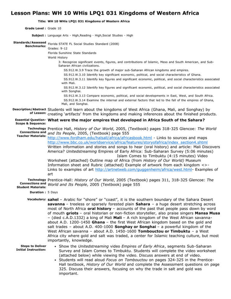
Lesson Plans: WH 10 WHis LPQ1 031 Kingdoms of Western Africa Title: WH 10 WHis LPQ1 031 Kingdoms of Western Africa Grade Level : Grade 10 Subject : Language Arts - High,Reading - High,Social Studies - High Standards/Assessed Florida STATE FL Social Studies Standard (2008) Benchmarks: Grades: 9-12 Florida Sunshine State Standards World History 3: Recognize significant events, figures, and contributions of Islamic, Meso and South American, and SubSaharan African civilizations. Description/Abstract of Lesson: Essential QuestionScope & Sequence: SS.912.W.3.9 Trace the growth of major sub-Saharan African kingdoms and empires. SS.912.W.3.10 Identify key significant economic, political, and social characteristics of Ghana. SS.912.W.3.11 Identify key figures and significant economic, political, and social characteristics associated with Mali. SS.912.W.3.12 Identify key figures and significant economic, political, and social characteristics associated with Songhai. SS.912.W.3.13 Compare economic, political, and social developments in East, West, and South Africa. SS.912.W.3.14 Examine the internal and external factors that led to the fall of the empires of Ghana, Mali, and Songhai. Students will learn about the kingdoms of West Africa (Ghana, Mali, and Songhay) by creating ‘artifacts’ from the kingdoms and making inferences about the finished products. What were the major empires that developed in Africa South of the Sahara? Technology Connections and Teacher Materials: Prentice Hall, History of Our World, 2005, (Textbook) pages 318-325 Glencoe: The World and Its People, 2005, (Textbook) page 555 http://www.fordham.edu/halsall/africa/africasbook.html - Links to sources and maps http://www.bbc.co.uk/worldservice/africa/features/storyofafrica/index_section4.shtml Written information and stories and songs to hear (oral history) and article: Mali Discovers America? Unitedstreaming Empires of Early Africa: Sub-Saharan Survey (5:06 minutes) Islam Comes to Timbuktu (4:15 minutes) Video Worksheet (attached) Outline map of Africa (from History of Our World) Museum Information sheet and Rubric (attached) Example of artwork from each kingdom <>Links to examples of art http://artnetweb.com/guggenheim/africa/west.html- Examples of art Technology Connections and Student Materials: Prentice-Hall: History of Our World, 2005 (Textbook) pages 311, 318-325 Glencoe: The World and Its People, 2005 (Textbook) page 555 Duration : 5 Days Vocabulary: sahel – Arabic for “shore” or “coast”, it is the southern boundary of the Sahara Desert savanna – treeless or sparsely forested plain Sahara – a huge desert stretching across most of North Africa oral history – accounts of the past that people pass down by word of mouth griots – oral historian or non-fiction storyteller, also praise singers Mansa Musa – (died c.A.D.1332) a king of Mali Mali – A rich kingdom of the West African savannaabout A.D. 1200-1450 Ghana – the first West African kingdom based on the gold and salt trades – about A.D. 400-1000 Songhay or Songhai – a powerful kingdom of the West African savanna – about A.D. 1450-1600 Tombouctou or Timbuktu – a West Africa city where gold and salt was traded, a center for Islamic teaching culture, but most importantly, knowledge. Steps to Deliver Initial Instruction: Show the Unitedstreaming video Empires of Early Africa, segments Sub-Saharan Survey and Islam Comes to Timbuktu. Students will complete the video worksheet (attached below) while viewing the video. Discuss answers at end of video. Students will read aloud Focus on Tombouctou on pages 324-325 in the PrenticeHall textbook, History of Our World and complete the Assessment questions on page 325. Discuss their answers, focusing on why the trade in salt and gold was important. Guided Practice with Feedback: On an outline map of Africa, students will locate the 3 kingdoms, Mali, Songhay, and Ghana (page 309 in textbook). The map will include a key and title. Students will add the cities and trade routes from the map on p. 325 in textbook. Add major trade routes, salt, and city symbols to key. If needed, map will be completed for homework. Collect completed map. Students will read aloud Critical Thinking Skill, page 555 in the Glencoe textbook, The World and Its People. As a class, complete the Practicing the Skill section. Individually,students will complete Applying the Skill. Discuss their answers. Introduce the Museum project. Students will work in groups of four to create a 3-D ‘artifact’ from Mali, Ghana, or Songhay. When completed it will be displayed in a class museum. Students from other groups will observe the ‘artifact’ and make an inference about the kingdom based on the ‘artifact.’ Independent Practice: Students will research their kingdom and begin work on their ‘artifact.’ Teacher should have examples of the artwork from each kingdom in the classroom. Although the artifact should reflect an accurate representation of the art of the kingdom, students may use paper mache instead of carving wood, etc. The ‘artifact’ will be on display in the class museum. Students will complete a worksheet for each artifact. Differentiated Instruction/Small Groups: Museum ‘artifact’ is in small groups. Students may demonstrate oral history by recording the history of a kingdom as a griot would do. Students may read p. 318-321 in Prentice-Hall textbook and the class can work on one artifact. Students could make a poster of examples of artwork from each kingdom. Artwork could be hand-drawn or downloaded from the computer. Artifacts from Bantu, Ile-Ife, BeninAksum, Lalibela, Kilwa, and Great Zimbabwe could be added to the museum. Students could add an example of the artwork from each kingdom to their map. Lesson Closure/Review: Assessment with Clear & Compelling Product Standards: Students will look at the map on page 311 in the Prentice-Hall textbook History of Our World and answer the following questions: What type of vegetation covered the kingdoms of Mali, Ghana, and Songhay? Locate the Sahara. Using your vocabulary, where do you think the Sahel is located? Infer – Why do you think the salt and gold trade developed in these kingdoms? How did Ghana become a major trading kingdom and why did Ghana’s power begin to fade? (p. 319 in Teacher’s Edition) Students will create a timeline for the kingdoms of Ghana, Mali, and Songhay (see page 321 in textbook). Students will list 3 important facts about each kingdom. Collect. Map: All kingdoms should be labeled, all cities, salt and trade routes should be labeled, key should include all symbols used, map should be correctly titled. Museum – see rubric Timeline: Dates should be accurate, dates should be evenly divided on timeline, 3 facts should be listed for each kingdom. Creator : Middle SS Content Team File Attachments: Artifact museum worksheet.pdf Video worksheet answer key.pdf video worksheet student copy.pdf Date Created : June 24, 2008 Date Modified : November 29, 2011
